IMAGES TAKEN NEAR TO
Uxbridge Road, LONDON, W12 7JA
Introduction
This page details the photographs taken nearby to Uxbridge Road, W12 7JA by members of the Geograph project.
The Geograph project started in 2005 with the aim of publishing, organising and preserving representative images for every square kilometre of Great Britain, Ireland and the Isle of Man.

There are currently over 7.5m images from over14,400 individuals and you can help contribute to the project by visiting https://www.geograph.org.uk
Image Map
Images are licensed for reuse under creativecommons.org/licenses/by-sa/2.0
Notes
- Clicking on the map will re-center to the selected point.
- The higher the marker number, the further away the image location is from the centre of the postcode.
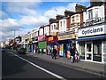
Image Listing (273 Images Found)
Images are licensed for reuse under creativecommons.org/licenses/by-sa/2.0
Image
Details
Distance
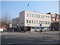
1
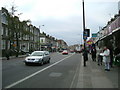
Uxbridge Road, W12
Uxbridge Road corner of Tunis Road looking towards East Acton.
Image: © Phillip Perry
Taken: 7 Feb 2008
0.00 miles
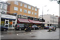
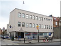

8
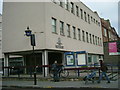
Shepherd's Bush Police Station
Shepherd's Bush Police Station, corner of Uxbridge Road and Tunis Road.
Image: © Phillip Perry
Taken: 7 Feb 2008
0.03 miles
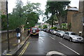
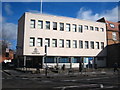
10
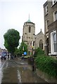
Church of St Stephen the Martyr
Grade II listed. http://www.britishlistedbuildings.co.uk/en-436213-church-of-st-stephen-the-martyr-and-st-t
Image: © N Chadwick
Taken: 24 May 2014
0.04 miles