IMAGES TAKEN NEAR TO
Bronze Walk, LONDON, W12 7HX
Introduction
This page details the photographs taken nearby to Bronze Walk, W12 7HX by members of the Geograph project.
The Geograph project started in 2005 with the aim of publishing, organising and preserving representative images for every square kilometre of Great Britain, Ireland and the Isle of Man.

There are currently over 7.5m images from over14,400 individuals and you can help contribute to the project by visiting https://www.geograph.org.uk
Image Map
Images are licensed for reuse under creativecommons.org/licenses/by-sa/2.0
Notes
- Clicking on the map will re-center to the selected point.
- The higher the marker number, the further away the image location is from the centre of the postcode.
Image Listing (300 Images Found)
Images are licensed for reuse under creativecommons.org/licenses/by-sa/2.0
Image
Details
Distance
1
Silver Road I, W12
These few centisquares have changed over the last few months with the construction of the new shopping centre.
Image: © Phillip Perry
Taken: 26 Oct 2008
0.02 miles
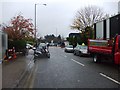
2
Ariel Way II, W12
The people in the hard hats and hi-vis jackets are not auditioning for a new Village People video, they are construction workers. But it's 7.40am on a Sunday and the last one before the new shopping centre opens on October 30th 2008. Will the mall open in/on time?????? The blocks of flats in the background are 2 of the 3 towerblocks of the Edward Woods Estate in the bottom right hand corner of this square, and the portakabins on the bridge on next to the West Cross Route. The bridge is part of an overhead roundabout junction built in 2000 - 8 years before the centre itself.
Image: © Phillip Perry
Taken: 26 Oct 2008
0.02 miles
3
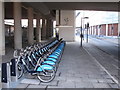
Boris bikes at Westfield, NE docking station
This docking station for Barclays cycle hire is by Ariel Way, underneath the flyover from the West Cross Route. Ariel Way runs round the outside of the shopping mall, from Wood Lane by the bus station to Shepherd's Bush by the tube and underground stations. A sign by the traffic light in the photo shows that cycling is allowed on the pavement.
Image: © David Hawgood
Taken: 11 Mar 2012
0.03 miles
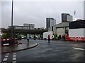
4
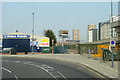
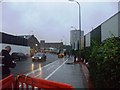
A3220 West Cross Route, White City
This was once designated as the M41. View is heading north towards the Northern Roundabout. The Metropolitan Line crosses over just ahead, and to the left, but out of view, is the line between Kensington Olympia and Willesden Junction.
This is not an easy feature to photograph as there are no overbridges anywhere along here that a pedestrian can use, and pedestrians and cycles are not permitted on the road itself. This photo was done from the top deck of a number 220 bus which was on diversion from its normal route along Wood Lane.
Image: © Danny P Robinson
Taken: 6 May 2007
0.03 miles
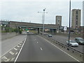
5
View from 31 bus on Ariel Way
A route primarily used by buses.
Image: © Robin Webster
Taken: 27 Mar 2011
0.04 miles
6
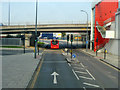
Ariel Way
A buses and deliveries only route by the Westfield shopping centre. The view is from the top of a 31 bus.
Image: © Robin Webster
Taken: 27 Mar 2011
0.04 miles
7
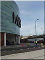
North-east corner of Westfield London
View across Westfield Way. Public access to the Marks and Spencer store is from inside the shopping mall, not from this area.
Image: © David Hawgood
Taken: 7 Nov 2008
0.05 miles
8
New road at Westfield Shopping Centre
This new road now joins Ariel Way which was a dead end
Image: © HENRY CLARK
Taken: 28 Mar 2009
0.05 miles
10
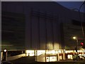
It looks like it will........ (see 1021853)
Contrast and compare with this picture Image, taken on 26/10/08 with the missing green panels, in this picture, the ones on the left side in the top right hand corner (if that makes any sense) were still being fitted at 4am this morning..... This was taken at 6.25am.
Image: © Phillip Perry
Taken: 30 Oct 2008
0.06 miles