IMAGES TAKEN NEAR TO
Stanlake Road, LONDON, W12 7HJ
Introduction
This page details the photographs taken nearby to Stanlake Road, W12 7HJ by members of the Geograph project.
The Geograph project started in 2005 with the aim of publishing, organising and preserving representative images for every square kilometre of Great Britain, Ireland and the Isle of Man.

There are currently over 7.5m images from over14,400 individuals and you can help contribute to the project by visiting https://www.geograph.org.uk
Image Map
Images are licensed for reuse under creativecommons.org/licenses/by-sa/2.0
Notes
- Clicking on the map will re-center to the selected point.
- The higher the marker number, the further away the image location is from the centre of the postcode.
Image Listing (287 Images Found)
Images are licensed for reuse under creativecommons.org/licenses/by-sa/2.0
Image
Details
Distance
2
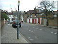
Loftus Road, W12
Taken from the end of Loftus Road in Batman Close looking south towards Uxbridge Road.
Image: © Phillip Perry
Taken: 19 Apr 2007
0.02 miles
3
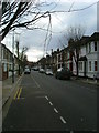
Abdale Road, W12
Looking down the whole length of Abdale Road
Image: © Phillip Perry
Taken: 7 Feb 2008
0.03 miles
5
Ellerslie Road, W12 (1)
Ellerslie Road between Loftus Road and Abdale Road, W12
Image: © Phillip Perry
Taken: 7 Feb 2008
0.03 miles
6
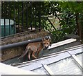
Hello Foxy
Taken from my kitchen window, she/he is on next-doors conservatory roof at 6.00am and one of 3 that howl, bark, screeeeech, play, fight, bite all night, but it's great.
All this and I'm about 3¾ miles from Marble Arch.
Image: © Phillip Perry
Taken: 23 Jun 2009
0.04 miles
7
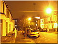
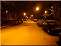
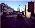
Stanlake Road, W12
Trying out my new camera more than anything else on ISO 1600 setting.
The row of houses facing are the back of the properties in Loftus Road, and one of the floodlight pylons from the QPR football ground.
Image: © Phillip Perry
Taken: 15 Dec 2009
0.05 miles
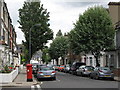
8
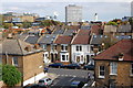
Abdale Road, Shepherds Bush
At its junction with Ellerslie Road. Taken from an apartment in Loftus Road. Behind (left) is the BBC TV Centre, and (right) part of Westfield Shopping Centre.
Image: © Trevor Harris
Taken: 25 Sep 2011
0.05 miles
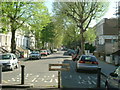
9
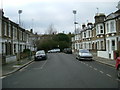
Stanlake Road, W12
Standing on the square boundary to square TQ2279, stanlake Road on the corner of Tunis Road, W12. The floodlights that can be seen are at the home end of Queen's Park Rangers FC.
Image: © Phillip Perry
Taken: 7 Feb 2008
0.05 miles
10
Ellerslie Road, W12 (2)
Looking west from the crossroads of Loftus Road
Image: © Phillip Perry
Taken: 8 Feb 2008
0.05 miles