IMAGES TAKEN NEAR TO
Ariel Way, LONDON, W12 7FD
Introduction
This page details the photographs taken nearby to Ariel Way, W12 7FD by members of the Geograph project.
The Geograph project started in 2005 with the aim of publishing, organising and preserving representative images for every square kilometre of Great Britain, Ireland and the Isle of Man.

There are currently over 7.5m images from over14,400 individuals and you can help contribute to the project by visiting https://www.geograph.org.uk
Image Map (Loading...)


Getting Data...Please wait
Leaflet Map data © OpenStreetMap
Images are licensed for reuse under creativecommons.org/licenses/by-sa/2.0
Notes
- Clicking on the map will re-center to the selected point.
- The higher the marker number, the further away the image location is from the centre of the postcode.
Image Listing (412 Images Found)
Images are licensed for reuse under creativecommons.org/licenses/by-sa/2.0
Image
Details
Distance
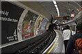
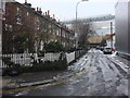
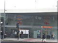
1
Outside Shepherd's Bush tube station
Image: © Oast House Archive
Taken: 9 Apr 2015
0.01 miles
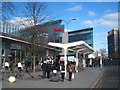
2
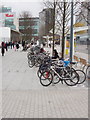
Cycle parking at Westfield
These are opposite the London Overground station at the southern approach to Westfield from Shepherd's Bush Green. There are hundreds of Sheffield stands for bikes.
Image: © David Hawgood
Taken: 6 Nov 2008
0.01 miles
3
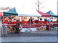
Italian market at Westfield
There were six stands selling a variety of Italian foods. The organisation La Dolce Vita takes the market around the country.
Image: © David Hawgood
Taken: 11 Mar 2012
0.01 miles
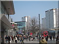
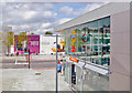
4
Shepherd's Bush Place
A small street with traditional terraced housing which has recently been surrounded by new buildings, at the end of the street is Westfield, London’s largest shopping centre and the silver building on the right is the recently rebuilt Shepherd's Bush tube station.
Image: © Oxyman
Taken: 4 Feb 2009
0.01 miles
5
Shepherd's Bush bus station
Incorporated in the Westfield shopping centre.
Image: © Rod Allday
Taken: 25 Feb 2012
0.01 miles
6
Exit from new Shepherds Bush Station, 2009
View westward onto Shepherds Bush Place: new station (opened 20/10/08) in place of former Uxbridge Road station, West London Line. (For details see Image]).
Image: © Ben Brooksbank
Taken: 27 Aug 2009
0.02 miles
7
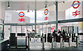
Exit through barriers at new Shepherds Bush Station, 2009
View SW onto A4020 Uxbridge Road: new station (opened 10/08) on West London Line on site of former Uxbridge Road Station (closed after bomb-damage in 10/40). (See Image] and other images).
Image: © Ben Brooksbank
Taken: 27 Aug 2009
0.02 miles
8
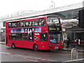
Transport Interchange
Outside Shepherd's Bush station, a double deck 237 bus is about to depart for Hounslow Heath.
http://www.tfl.gov.uk/corporate/modesoftransport/1574.aspx
Image: © Colin Smith
Taken: 12 Jun 2012
0.02 miles
9
Shepherd's Bush Railway Station, Uxbridge Road W12
Image: © Robin Sones
Taken: 10 Jun 2009
0.02 miles