IMAGES TAKEN NEAR TO
Wood Lane, LONDON, W12 7FB
Introduction
This page details the photographs taken nearby to Wood Lane, W12 7FB by members of the Geograph project.
The Geograph project started in 2005 with the aim of publishing, organising and preserving representative images for every square kilometre of Great Britain, Ireland and the Isle of Man.

There are currently over 7.5m images from over14,400 individuals and you can help contribute to the project by visiting https://www.geograph.org.uk
Image Map
Images are licensed for reuse under creativecommons.org/licenses/by-sa/2.0
Notes
- Clicking on the map will re-center to the selected point.
- The higher the marker number, the further away the image location is from the centre of the postcode.
Image Listing (327 Images Found)
Images are licensed for reuse under creativecommons.org/licenses/by-sa/2.0
Image
Details
Distance
1
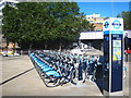
Cycle hire stand at White City bus station
Image: © Rod Allday
Taken: 18 Aug 2012
0.00 miles
2
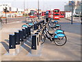
Boris bikes at Westfield, NW docking station
This docking station is on Wood Lane where Ariel Way joins it. It is by the White City bus station, and near Wood Lane and White City tube stations.
Image: © David Hawgood
Taken: 11 Mar 2012
0.01 miles
3
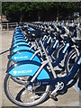
'Boris Bikes' at White City bus station
Plenty available first thing in the morning.
Image: © Rod Allday
Taken: 18 Aug 2012
0.01 miles
4
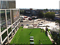
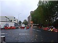
White City Bus Station and Westfield London Square
The green is the activities area of the public square of Westfield London shopping centre. Beyond is the Transport for London bus station which is part of the development. Beyond the bus station, across Wood Lane, is the Television Centre multi-storey car park. On the building on the left is a full-motion advertising screen of 220 square metres. View from terrace of John Lewis store. See Image for a ground-level view of the bus station.
Image: © David Hawgood
Taken: 25 Aug 2019
0.01 miles
5
Wood Lane III, W12
Junction with Ariel Way.
Image: © Phillip Perry
Taken: 26 Oct 2008
0.02 miles
6
whitecity Shopping Centre
whitecity Shopping Centre another part of the site taken from Wood Lane near Ariel Way. Compare with picture Image
(NOTE to mods - whitecity is whitecity and not White City, Whitecity or WhiteCity, that is how it is advertised.....)
Image: © Phillip Perry
Taken: 30 Jan 2008
0.02 miles
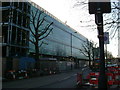
7
Wood Lane by the railway bridge
The car park on the right is used for some Queens Park Rangers home matches. The old BBC studios are on the left past the bridge but now privately owned.
Image: © David Howard
Taken: 6 Jan 2014
0.02 miles
8
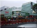
Westfield whitecity shopping centre
These few centisquares have changed over the last few months with the construction of the new shopping centre. Looking towards the Westfield shopping centre due to open on Thursday October 30 2008. But will it?????
Taken from Wood Lane close to Ariel Way, compare with picture Image
Image: © Phillip Perry
Taken: 26 Oct 2008
0.03 miles
9

Superloop 8 bus at White City bus station
The map on the side of the bus shows the route Uxbridge - Hayes - Ealing Hospital - Ealing Broadway - White City.
This is a radial route of the Superloop. At Hayes it crosses an existing route round the loop, SL9 from Heathrow to Harrow. Other routes are being added.
Image: © David Hawgood
Taken: 18 Aug 2023
0.03 miles
10
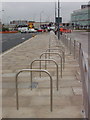
Bike racks at north-west of Westfield
These Sheffield stands are by Ariel Way and the new Wood Green tube station. They will be next to the bus station, but that is not in use yet. At present most cyclists are arriving from Shepherd's Bush Green, and the cycle racks there are already well used, see Image
Image: © David Hawgood
Taken: 6 Nov 2008
0.03 miles