IMAGES TAKEN NEAR TO
Westway, LONDON, W12 0SH
Introduction
This page details the photographs taken nearby to Westway, W12 0SH by members of the Geograph project.
The Geograph project started in 2005 with the aim of publishing, organising and preserving representative images for every square kilometre of Great Britain, Ireland and the Isle of Man.

There are currently over 7.5m images from over14,400 individuals and you can help contribute to the project by visiting https://www.geograph.org.uk
Image Map
Images are licensed for reuse under creativecommons.org/licenses/by-sa/2.0
Notes
- Clicking on the map will re-center to the selected point.
- The higher the marker number, the further away the image location is from the centre of the postcode.
Image Listing (111 Images Found)
Images are licensed for reuse under creativecommons.org/licenses/by-sa/2.0
Image
Details
Distance
1
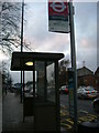
Bus Stop - Westway
A request stop for London bus route 95 heading towards Hanger Lane terminating in Greenford.
Image: © Phillip Perry
Taken: 7 Feb 2008
0.03 miles
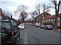
2
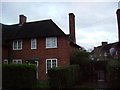
13 Lilac Street, W12
A 4 bedroom house in this street, front and back garden (but not this house - went for in October 2007 £750,000). Not bad for ex-council stock, hey?
Image: © Phillip Perry
Taken: 7 Feb 2008
0.03 miles
3
Pansy Gardens, W12
Pansy Gardens, a quiet cul-de-sac off The Curve, W12.
Image: © Phillip Perry
Taken: 9 Jun 2008
0.03 miles
4
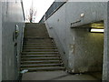
A40 - Westway subway
A pedestrian subway entrance under Westway - South Side.
Image: © Phillip Perry
Taken: 7 Feb 2008
0.04 miles
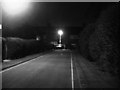
5
Sundew Avenue, W12
Part of the Wormholt housing estate.
Image: © Phillip Perry
Taken: 7 Feb 2008
0.06 miles
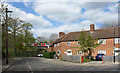
7
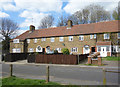
Primula Street, Acton
Part of an extensive Garden City influenced residential area developed by London County Council from 1912 to 1928.
More details on https://en.wikipedia.org/wiki/Old_Oak_and_Wormholt
Image: © Des Blenkinsopp
Taken: 13 Apr 2017
0.07 miles
8
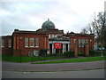
The Curve, Wormholt Estate
The building was a former library, now it's a nursery.
Image: © Phillip Perry
Taken: 7 Feb 2008
0.07 miles
9
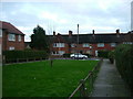
Westway, W12
Taken from Westway, a small green surrounded by 8 houses, looking towards Lilac Street, W12.
Image: © Phillip Perry
Taken: 7 Feb 2008
0.08 miles
10
Corner of Primula Street
Part of an extensive Garden City influenced residential area developed by London County Council from 1912 to 1928.
More information on https://en.wikipedia.org/wiki/Old_Oak_and_Wormholt
Image: © Des Blenkinsopp
Taken: 13 Apr 2017
0.08 miles