IMAGES TAKEN NEAR TO
Sundew Avenue, LONDON, W12 0RN
Introduction
This page details the photographs taken nearby to Sundew Avenue, W12 0RN by members of the Geograph project.
The Geograph project started in 2005 with the aim of publishing, organising and preserving representative images for every square kilometre of Great Britain, Ireland and the Isle of Man.

There are currently over 7.5m images from over14,400 individuals and you can help contribute to the project by visiting https://www.geograph.org.uk
Image Map (Loading...)


Getting Data...Please wait
Leaflet Map data © OpenStreetMap
Images are licensed for reuse under creativecommons.org/licenses/by-sa/2.0
Notes
- Clicking on the map will re-center to the selected point.
- The higher the marker number, the further away the image location is from the centre of the postcode.
Image Listing (138 Images Found)
Images are licensed for reuse under creativecommons.org/licenses/by-sa/2.0
Image
Details
Distance
3
Westway, W12
Taken from Westway, a small green surrounded by 8 houses, looking towards Lilac Street, W12.
Image: © Phillip Perry
Taken: 7 Feb 2008
0.02 miles
5
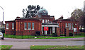
Public Library, Westway, East Acton, W12 -
Image: © John Salmon
Taken: 17 Nov 2004
0.06 miles
6
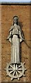
St Katherine, Westway, London W12 - Exterior sculpture
St Katherine
Image: © John Salmon
Taken: 5 Nov 2004
0.07 miles
7
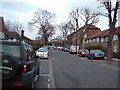
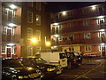
Sundew Avenue, W12
Part of the Wormholt housing estate.
Image: © Phillip Perry
Taken: 7 Feb 2008
0.07 miles
8
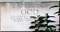
St Katherine, Westway, London W12 - Foundation stone
Image: © John Salmon
Taken: 5 Nov 2004
0.07 miles
9
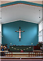
St Katherine, Westway, East Acton, W12 - Sanctuary
Image: © John Salmon
Taken: 17 Nov 2004
0.07 miles
10
Creighton Close, Bloemfontein Road, W12
Part of the White City Estate, Creighton Close.
Image: © Phillip Perry
Taken: 9 Jun 2008
0.07 miles