IMAGES TAKEN NEAR TO
Sedgeford Road, LONDON, W12 0NA
Introduction
This page details the photographs taken nearby to Sedgeford Road, W12 0NA by members of the Geograph project.
The Geograph project started in 2005 with the aim of publishing, organising and preserving representative images for every square kilometre of Great Britain, Ireland and the Isle of Man.

There are currently over 7.5m images from over14,400 individuals and you can help contribute to the project by visiting https://www.geograph.org.uk
Image Map
Images are licensed for reuse under creativecommons.org/licenses/by-sa/2.0
Notes
- Clicking on the map will re-center to the selected point.
- The higher the marker number, the further away the image location is from the centre of the postcode.
Image Listing (78 Images Found)
Images are licensed for reuse under creativecommons.org/licenses/by-sa/2.0
Image
Details
Distance
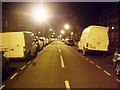
2
Sedgeford Road, W12
Sedgeford Road corner of Aldbourne Road, W12
Image: © Phillip Perry
Taken: 29 Feb 2008
0.08 miles
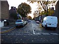
4
Sawley Road, W12
Sawley Road looking towards Wormholt Road.
Image: © Phillip Perry
Taken: 9 Jun 2008
0.08 miles
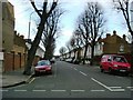
5
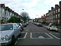
Aycliffe Road, W12
Aycliffe Road, W12
Image: © Phillip Perry
Taken: 29 Feb 2008
0.08 miles
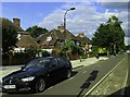
6
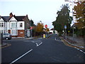
Steventon Road II, W12
Junction of Steventon Road, Sedgeford Road & Wallflower Street. Also see: Image
Image: © Phillip Perry
Taken: 9 Nov 2008
0.09 miles
7
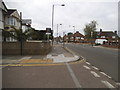
Old Oak Road at the junction of Ashfield Road
Image: © David Howard
Taken: 13 Jun 2015
0.09 miles
8
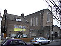
Buttercups Day Nursery Old Oak Road
The nursery is housed in the former vicarage of St Saviours Church next door.
Image: © PAUL FARMER
Taken: 13 Feb 2010
0.09 miles
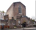
9
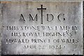
St Saviour, Old Oak Road. London W3 - Foundation stone
Image: © John Salmon
Taken: 5 Nov 2004
0.10 miles