IMAGES TAKEN NEAR TO
Pioneer Way, LONDON, W12 0EZ
Introduction
This page details the photographs taken nearby to Pioneer Way, W12 0EZ by members of the Geograph project.
The Geograph project started in 2005 with the aim of publishing, organising and preserving representative images for every square kilometre of Great Britain, Ireland and the Isle of Man.

There are currently over 7.5m images from over14,400 individuals and you can help contribute to the project by visiting https://www.geograph.org.uk
Image Map
Images are licensed for reuse under creativecommons.org/licenses/by-sa/2.0
Notes
- Clicking on the map will re-center to the selected point.
- The higher the marker number, the further away the image location is from the centre of the postcode.
Image Listing (103 Images Found)
Images are licensed for reuse under creativecommons.org/licenses/by-sa/2.0
Image
Details
Distance
3
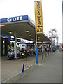
Du Cane Road - Petrol Station
Gulf filling station in Du Cane Road, W12
Image: © Phillip Perry
Taken: 7 Feb 2008
0.05 miles
5
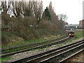
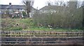
Central Line
Off Du Cane Road looking towards East Acton station, with a train bound for White City.
Image: © Phillip Perry
Taken: 7 Feb 2008
0.06 miles
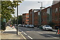
7
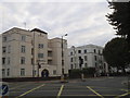
Flats on Du Cane Road, Shepherds Bush
On the corner of Scrubs Lane
Image: © David Howard
Taken: 27 Sep 2014
0.07 miles
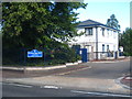
8
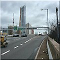
A40 flyover towards central London
Trunk road north of Shepherd's Bush.
Image: © James Emmans
Taken: 12 Mar 2023
0.09 miles