IMAGES TAKEN NEAR TO
Osmund Street, LONDON, W12 0AX
Introduction
This page details the photographs taken nearby to Osmund Street, W12 0AX by members of the Geograph project.
The Geograph project started in 2005 with the aim of publishing, organising and preserving representative images for every square kilometre of Great Britain, Ireland and the Isle of Man.

There are currently over 7.5m images from over14,400 individuals and you can help contribute to the project by visiting https://www.geograph.org.uk
Image Map
Images are licensed for reuse under creativecommons.org/licenses/by-sa/2.0
Notes
- Clicking on the map will re-center to the selected point.
- The higher the marker number, the further away the image location is from the centre of the postcode.
Image Listing (83 Images Found)
Images are licensed for reuse under creativecommons.org/licenses/by-sa/2.0
Image
Details
Distance
1
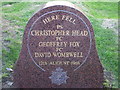
Braybrook Street memorial
This stone remembers 3 policemen who were murdered in this part of Shepherd's Bush, 43 years ago today.
Image: © Phillip Perry
Taken: 12 Aug 2009
0.08 miles
2
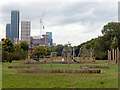
Wormwood Scrubs
Known as The Scrubs locally, Wormwood Scrubs is an open space covering 67 hectares (166 acres). This view incorporates a children's playground with a backdrop of the towers mushrooming at North Acton which have been described as west London's 'mini Manhattan'.
Image: © Stephen McKay
Taken: 30 Sep 2022
0.08 miles
3
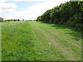
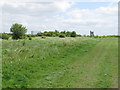
Hedge and track in Wormwood Scrubs beside Braybrook Street
Trellick Tower visible on the skyline.
Image: © David Hawgood
Taken: 16 May 2015
0.08 miles
5
Wormwood Scrubs, view to Kensal Green gasometer & Trellick Tower
Viewpoint is beside Braybrook Street. The Central Woodland Copse of Wormwood Scrubs is to the right of the gasometer.
Image: © David Hawgood
Taken: 16 May 2015
0.11 miles
6
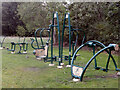
Outdoor gym - Wormwood Scrubs
Across most of the country Wormwood Scrubs is known for the prison but in fact there is also an open common covering 67 hectares (166 acres) which is designated a local nature reserve. Under the Wormwood Scrubs Act 1879 the land was designated as a training ground for the military but also provided for 'the perpetual use by the inhabitants of the metropolis for exercise and recreation'. This outdoor gym close to Braybrook Street offers the option of exercise.
Image: © Stephen McKay
Taken: 30 Sep 2022
0.11 miles
7
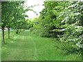
Avenue beside Braybrook Street
The hedge on the right is beside Wormwood Scrubs. The street is on the left beyond the trees.
Image: © David Hawgood
Taken: 16 May 2015
0.12 miles
8
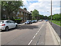
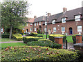
Houses in Braybrook Street, Hammersmith and Fulham
The street is beside Wormwood Scrubs park.
Image: © David Hawgood
Taken: 16 May 2015
0.13 miles
9
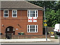
House displays flag to support England football at Euros
Football European Championships were delayed because of the coronavirus, in June 2021 were in progress, this house by Old Oak Common had the England flag of St. George hanging from a window to show support.
Image: © David Hawgood
Taken: 24 Jun 2021
0.13 miles
10
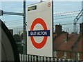
East Acton station
Taken from a "1992 stock" - Central Line train, westbound platform.
East Acton station, Erconwald Street W12, the houses behind are in Fitzneal Street.
Image: © Phillip Perry
Taken: 27 Aug 2007
0.14 miles