IMAGES TAKEN NEAR TO
Mellitus Street, LONDON, W12 0AU
Introduction
This page details the photographs taken nearby to Mellitus Street, W12 0AU by members of the Geograph project.
The Geograph project started in 2005 with the aim of publishing, organising and preserving representative images for every square kilometre of Great Britain, Ireland and the Isle of Man.

There are currently over 7.5m images from over14,400 individuals and you can help contribute to the project by visiting https://www.geograph.org.uk
Image Map (Loading...)


Getting Data...Please wait
Leaflet Map data © OpenStreetMap
Images are licensed for reuse under creativecommons.org/licenses/by-sa/2.0
Notes
- Clicking on the map will re-center to the selected point.
- The higher the marker number, the further away the image location is from the centre of the postcode.
Image Listing (88 Images Found)
Images are licensed for reuse under creativecommons.org/licenses/by-sa/2.0
Image
Details
Distance
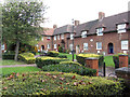
2
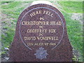
Braybrook Street memorial
This stone remembers 3 policemen who were murdered in this part of Shepherd's Bush, 43 years ago today.
Image: © Phillip Perry
Taken: 12 Aug 2009
0.09 miles
3
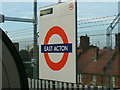
East Acton station
Taken from a "1992 stock" - Central Line train, westbound platform.
East Acton station, Erconwald Street W12, the houses behind are in Fitzneal Street.
Image: © Phillip Perry
Taken: 27 Aug 2007
0.10 miles
4
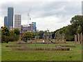
Wormwood Scrubs
Known as The Scrubs locally, Wormwood Scrubs is an open space covering 67 hectares (166 acres). This view incorporates a children's playground with a backdrop of the towers mushrooming at North Acton which have been described as west London's 'mini Manhattan'.
Image: © Stephen McKay
Taken: 30 Sep 2022
0.10 miles
5
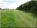
Hedge and track in Wormwood Scrubs beside Braybrook Street
Trellick Tower visible on the skyline.
Image: © David Hawgood
Taken: 16 May 2015
0.10 miles
6
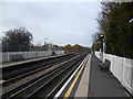
East Acton station
East Acton station opened on 3rd August 1920 on the Ealing Broadway extension of the Central London Railway to serve the nearby London County Council housing estate which had started in 1912. The Central London Railway was renamed the Central line in 1937.
This view is of the up platform looking in the direction of West Ruislip and Ealing Broadway. There is just a small shelter on this platform. The next station in this direction is North Acton.
Image: © Marathon
Taken: 27 Nov 2013
0.11 miles
7
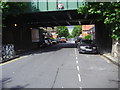
Railway Bridge, Erconwald Street
The Central Line runs from East Acton Station on the left, which is actually in W12 which is technically Shepherds Bush
Image: © David Howard
Taken: 10 Jul 2008
0.12 miles

9
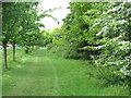
Avenue beside Braybrook Street
The hedge on the right is beside Wormwood Scrubs. The street is on the left beyond the trees.
Image: © David Hawgood
Taken: 16 May 2015
0.12 miles
