IMAGES TAKEN NEAR TO
Wulfstan Street, LONDON, W12 0AH
Introduction
This page details the photographs taken nearby to Wulfstan Street, W12 0AH by members of the Geograph project.
The Geograph project started in 2005 with the aim of publishing, organising and preserving representative images for every square kilometre of Great Britain, Ireland and the Isle of Man.

There are currently over 7.5m images from over14,400 individuals and you can help contribute to the project by visiting https://www.geograph.org.uk
Image Map
Images are licensed for reuse under creativecommons.org/licenses/by-sa/2.0
Notes
- Clicking on the map will re-center to the selected point.
- The higher the marker number, the further away the image location is from the centre of the postcode.
Image Listing (95 Images Found)
Images are licensed for reuse under creativecommons.org/licenses/by-sa/2.0
Image
Details
Distance
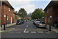
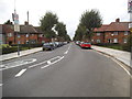
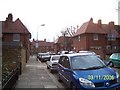
3
Wulfstan Street, W12
A rat run between Du Cane Road and Old Oak Common Lane.
Image: © Phillip Perry
Taken: 30 Jan 2008
0.06 miles
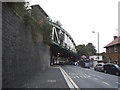
4
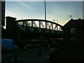
Central Line railway bridge, Du Cane Road, W12
Looking west towards East Acton, on the corner of Wulfstan Street.
Image: © Phillip Perry
Taken: 30 Jan 2008
0.07 miles
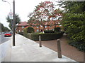
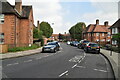
8
Braybrook Street
Braybrook Street looking towards Wulfstan Street
Image: © Todd Keator
Taken: 11 Mar 2006
0.08 miles
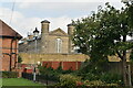
9
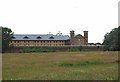
HMP Wormwood Scrubs
One of Her Majesty’s finest hotels with room for 1279 residents see http://www.justice.gov.uk/contacts/prison-finder/wormwood-scrubs for more info.
Image: © Glyn Baker
Taken: 18 Jul 2012
0.09 miles