IMAGES TAKEN NEAR TO
Norland Road, LONDON, W11 4TR
Introduction
This page details the photographs taken nearby to Norland Road, W11 4TR by members of the Geograph project.
The Geograph project started in 2005 with the aim of publishing, organising and preserving representative images for every square kilometre of Great Britain, Ireland and the Isle of Man.

There are currently over 7.5m images from over14,400 individuals and you can help contribute to the project by visiting https://www.geograph.org.uk
Image Map
Images are licensed for reuse under creativecommons.org/licenses/by-sa/2.0
Notes
- Clicking on the map will re-center to the selected point.
- The higher the marker number, the further away the image location is from the centre of the postcode.
Image Listing (384 Images Found)
Images are licensed for reuse under creativecommons.org/licenses/by-sa/2.0
Image
Details
Distance
2
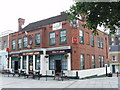
The Stewart Arms, Norland Road, Hammersmith
This is just opposite the subway from Shepherd's Bush and White City.
Image: © David Hawgood
Taken: 21 Aug 2008
0.01 miles
3
The Stewart Arms public house, Norland Road, London
Image: © PAUL FARMER
Taken: 11 Jun 2011
0.02 miles
4
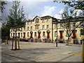
The Stewart Arms (1), 26 Norland Road, Notting Hill, London
Traditional public house with many retro features inside including disused gas-light fittings. The area adjacent to the pub has been pedestrianised and it is conveniently located for the nearby Westfield shopping area. This used to be a Courage house and still sells Courage Best bitter. Currently however it is owned by Enterprise Inns. Records show that this pub was here in 1867 and almost certainly earlier.
In recent years the exterior signage has changed and it has been repainted. How it used to look can be seen in this August 2008 photograph by David Hawgood. Note the traditional Courage cockerel sign, which sadly is no longer there:- Image
Image
Image: © L S Wilson
Taken: 6 Jul 2016
0.02 miles
5
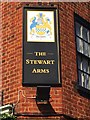
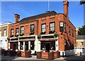
The Stewart Arms (2) - sign, 26 Norland Road, Notting Hill, London
The sign is attached to a wall of the pub and shows the coat of arms of the Stewart family, who presumably were local landowners. Until recent years there was a traditional red Courage cockerel sign displayed here but that has now gone.
Image
Image: © L S Wilson
Taken: 6 Jul 2016
0.02 miles
6
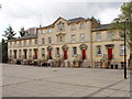
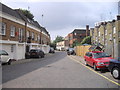
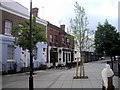
Stone-faced terrace in Norland Road, Hammersmith
This mid 19th Century terrace was moved and reconstructed in 1977-9 after the West Cross route truncated it. Pevsner and Cherry in "Buildings of England" say it "has curiously elaborate details, pedimented doorways, central gable, windows and cornice with paired brackets."
Image: © David Hawgood
Taken: 21 Aug 2008
0.02 miles
9
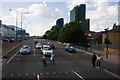
West Cross Route
The A3220 - a short length of dual carriageway connecting Shepherds Bush with the A40 Westway, seen from the top deck of a passing bus.
Image: © Martin Addison
Taken: 17 Jul 2010
0.03 miles
10
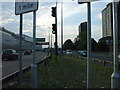
West Cross Route, W12 - A3220
Until recently you wouldn't have been able to do this legally, cross this road at street level, this former motorway was downgraded to an A road in 2000, and now thankfully people don't have to use the awful dodgy subways dotted around this roundabout anymore.
Image: © Phillip Perry
Taken: 25 Jun 2009
0.03 miles