IMAGES TAKEN NEAR TO
Queensdale Crescent, LONDON, W11 4TQ
Introduction
This page details the photographs taken nearby to Queensdale Crescent, W11 4TQ by members of the Geograph project.
The Geograph project started in 2005 with the aim of publishing, organising and preserving representative images for every square kilometre of Great Britain, Ireland and the Isle of Man.

There are currently over 7.5m images from over14,400 individuals and you can help contribute to the project by visiting https://www.geograph.org.uk
Image Map
Images are licensed for reuse under creativecommons.org/licenses/by-sa/2.0
Notes
- Clicking on the map will re-center to the selected point.
- The higher the marker number, the further away the image location is from the centre of the postcode.
Image Listing (211 Images Found)
Images are licensed for reuse under creativecommons.org/licenses/by-sa/2.0
Image
Details
Distance
1
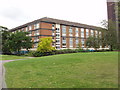
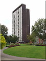
Maisonettes, Edward Woods estate, Hammersmith
The maisonettes with garages underneath are Mortimer House, part of the 1960s Edward Woods Estate designed by Hammersmith Borough Architect's department. Part of the 21 storey Poynter House is on the right. The estate has areas of lawn and trees between the buildings.
Image: © David Hawgood
Taken: 21 Aug 2008
0.00 miles
2
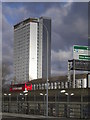
Tower block, Shepherds Bush
Photographed from the eastern side of Westfield Shopping Complex
Image: © Andrew Wilson
Taken: 2 Feb 2013
0.06 miles
3
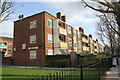
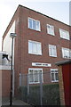
Dorrit House, St Anns Road
In 1973 the Ordnance Survey levelled a cut mark benchmark at 7.08m above Newlyn Datum on the facing corner. It is probably still there, but hidden from public view behind the wooden fence.
Image: © Roger Templeman
Taken: 10 Mar 2012
0.06 miles
4
Edward Woods Estate, Shepherds Bush
Showing Stebbing House (foreground, partially obscured by tree), Boxmoor House is the low rise in the centre and Norland House is the tower block at the rear. This estate is owned and managed by Hammersmith and Fulham Council.
Image: © Danny P Robinson
Taken: 29 Apr 2007
0.06 miles
5
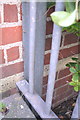
Partially obscured benchmark on #19-24 Dorrit House
Ordnance Survey cut mark benchmark described on the Bench Mark Database at http://www.bench-marks.org.uk/bm41929
Image: © Roger Templeman
Taken: 10 Mar 2012
0.06 miles
6
Flats #19-24 Dorrit House, St Anns Road
There is an OS benchmark Image on the corner of the building where the metal fence is secured to it
Image: © Roger Templeman
Taken: 10 Mar 2012
0.06 miles
7
Stebbing House, 21 storey block of flats in Hammersmith
This 1960s tower block on the Edward Woods estate was designed by Hammersmith Borough Architect's Department.
Image: © David Hawgood
Taken: 21 Aug 2008
0.06 miles
8
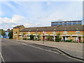
Terrace housing, Hunt Close, Kensington and Chelsea
Just by the boundary to Hammersmith and Fulham.
Image: © David Hawgood
Taken: 16 Sep 2023
0.07 miles
9
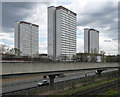
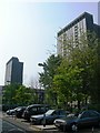
Edward Woods Estate, Queensland Crescent
Three twenty-one storey slab blocks, Poynter, Stebbing and Norland, built in 1964-66 by Hammersmith Borough Architect's Department (the estate was named after the mayor). They look as if they have been re-clad fairly recently (see 2008 view Image]). Lower blocks between.
In front is the railway, currently branded as part of the London Overground network connecting Clapham Junction/Richmond with north London.
Image: © Stephen Richards
Taken: 30 Apr 2016
0.07 miles
10
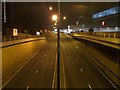
A3220 - West Cross Route, W12
A few short hours from the road above the A3220 was open and before the Westfield London shopping centre, and a rare opportunity to take a picture above the former M41 motorway as pedestrians were not allowed here or on the road below, although the slope on the left was an unofficial bus stand for a few months. This junction has been here for 8 years (with working traffic lights for a time) before it was connected to anything. The only other time you would've been able to see it was in the film Johnny English starring Rowan Atkinson.
Image: © Phillip Perry
Taken: 30 Oct 2008
0.07 miles