IMAGES TAKEN NEAR TO
Swanscombe Road, LONDON, W11 4SU
Introduction
This page details the photographs taken nearby to Swanscombe Road, W11 4SU by members of the Geograph project.
The Geograph project started in 2005 with the aim of publishing, organising and preserving representative images for every square kilometre of Great Britain, Ireland and the Isle of Man.

There are currently over 7.5m images from over14,400 individuals and you can help contribute to the project by visiting https://www.geograph.org.uk
Image Map
Images are licensed for reuse under creativecommons.org/licenses/by-sa/2.0
Notes
- Clicking on the map will re-center to the selected point.
- The higher the marker number, the further away the image location is from the centre of the postcode.
Image Listing (297 Images Found)
Images are licensed for reuse under creativecommons.org/licenses/by-sa/2.0
Image
Details
Distance
1
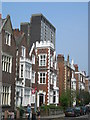
St Ann's Villas, W11
A striking parade of houses, with a tower block on the Edward Woods Estate Image in the background.
Image: © Danny P Robinson
Taken: 29 Apr 2007
0.01 miles
2
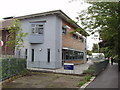
Edward Woods Community Centre, Hammersmith
The community centre for the Edward Woods estate of Hammersmith and Fulham.
Image: © David Hawgood
Taken: 21 Aug 2008
0.02 miles
3
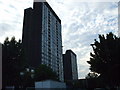
Norland House & Stebbing House, W11
Norland House is in the foreground, one of three identical 22-storey towerblocks, forming part of the Edward Woods estate.
Image: © Phillip Perry
Taken: 25 Jun 2009
0.04 miles
4
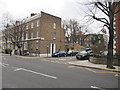
Junction of St James Gardens and St Annes's Villas
Image: © Richard Rogerson
Taken: 4 Apr 2013
0.04 miles
5
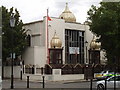
Sikh temple, Queensdale Road, Hammersmith
The Central Gurdwara (Kalsa Jatha) London http://www.centralgurdwara.org.uk/ was founded in 1908 and moved to this site on the corner of Queensdale and Norland roads in 1969. The domes were added in the 1990s.
Image: © David Hawgood
Taken: 21 Aug 2008
0.05 miles
6
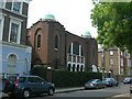
Spanish & Portuguese Synagogue, St. James's Gardens, W11
Address is 8 St. James's Gardens, London W11 4RB
Image: © Danny P Robinson
Taken: 29 Apr 2007
0.06 miles
7
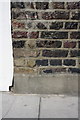
Benchmark on #16 St Anns Road
Ordnance Survey cut mark benchmark described on the Bench Mark Database at http://www.bench-marks.org.uk/bm41930
Image: © Roger Templeman
Taken: 10 Mar 2012
0.06 miles
8
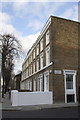
Houses of St Anns Road at Darnley Terrace junction
There is an OS benchmark Image on the house wall below the road name sign
Image: © Roger Templeman
Taken: 10 Mar 2012
0.06 miles
9
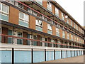
Maisonettes over garages, Hammersmith
This is Boxmoor House on the Edward Woods estate. Maisonettes all have two floors, with front doors from 1st and 3rd floor outside walkways.
Image: © David Hawgood
Taken: 21 Aug 2008
0.06 miles
10
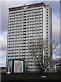
Another tower block, Shepherds Bush
I like the contrast between the austere building and the advertising poster.
Image: © Andrew Wilson
Taken: 2 Feb 2013
0.07 miles