IMAGES TAKEN NEAR TO
Queensdale Road, LONDON, W11 4SB
Introduction
This page details the photographs taken nearby to Queensdale Road, W11 4SB by members of the Geograph project.
The Geograph project started in 2005 with the aim of publishing, organising and preserving representative images for every square kilometre of Great Britain, Ireland and the Isle of Man.

There are currently over 7.5m images from over14,400 individuals and you can help contribute to the project by visiting https://www.geograph.org.uk
Image Map
Images are licensed for reuse under creativecommons.org/licenses/by-sa/2.0
Notes
- Clicking on the map will re-center to the selected point.
- The higher the marker number, the further away the image location is from the centre of the postcode.
Image Listing (289 Images Found)
Images are licensed for reuse under creativecommons.org/licenses/by-sa/2.0
Image
Details
Distance
1
Motorbike parking with secure locking, Kensington
The introduction of the congestion charge has seen a big increase in the use of motorbikes in London. The Royal Borough of Kensington and Chelsea is making on-street secure motorcycle parking available to residents - see http://www.rbkc.gov.uk/EnvironmentalServices/parking/motorcycles.asp . The one shown, about to come into use, is in St Anne's Villas, just by Royal Crescent. Each of the six street-level studs has a hinged D-ring to take a chain locking the motorbike.
Image: © David Hawgood
Taken: 3 May 2008
0.03 miles
2
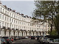
Royal Crescent, Norland Estate, Kensington
This crescent was laid out by Robert Cantwell in 1846 as part of the Norland Estate, to be similar to crescents in Regent's Park and Bath.
Image: © David Hawgood
Taken: 3 May 2008
0.04 miles
3
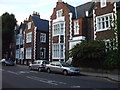
St. Ann's Villas, W11
Some strange looking houses along here.
Image: © Phillip Perry
Taken: 25 Jun 2009
0.05 miles
5
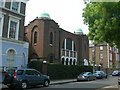
Spanish & Portuguese Synagogue, St. James's Gardens, W11
Address is 8 St. James's Gardens, London W11 4RB
Image: © Danny P Robinson
Taken: 29 Apr 2007
0.05 miles
6
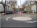
Road closure
Addison Avenue leading to St James's Church Norlands.
Image: © Peter Holmes
Taken: 4 Mar 2009
0.06 miles

8
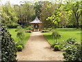
Garden square of Royal Crescent, Kensington
This garden is between Royal Crescent and Holland Park Avenue. It is a private garden available to residents of houses in the crescent; they pay for its upkeep through an addition to their council tax. Like many garden squares in the area, it is regulated under the Kensington Improvement Act 1851.
Image: © David Hawgood
Taken: 3 May 2008
0.06 miles
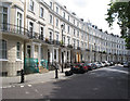
9
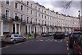
Royal Crescent, Kensington
Inspired by its namesake in Bath this crescent of houses was built in the 1840s to a design by Robert Cantwell. The terrace is grade II listed and overlooks a private communal garden.
Image: © Stephen McKay
Taken: 23 Mar 2019
0.06 miles
10
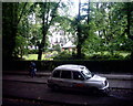
Royal Crescent communal gardens, W11
Like a lot of squares and crescents in the area only people who live in that particular street have access to their own almost private communal gardens. The parked taxi pictured is opposite the Hilton London Kensington hotel in Holland Park Avenue. Taken from the top deck of a 148 bus.
Image: © Phillip Perry
Taken: 12 Jun 2008
0.06 miles