IMAGES TAKEN NEAR TO
St. Anns Villas, LONDON, W11 4RU
Introduction
This page details the photographs taken nearby to St. Anns Villas, W11 4RU by members of the Geograph project.
The Geograph project started in 2005 with the aim of publishing, organising and preserving representative images for every square kilometre of Great Britain, Ireland and the Isle of Man.

There are currently over 7.5m images from over14,400 individuals and you can help contribute to the project by visiting https://www.geograph.org.uk
Image Map
Images are licensed for reuse under creativecommons.org/licenses/by-sa/2.0
Notes
- Clicking on the map will re-center to the selected point.
- The higher the marker number, the further away the image location is from the centre of the postcode.
Image Listing (342 Images Found)
Images are licensed for reuse under creativecommons.org/licenses/by-sa/2.0
Image
Details
Distance
1
Motorbike parking with secure locking, Kensington
The introduction of the congestion charge has seen a big increase in the use of motorbikes in London. The Royal Borough of Kensington and Chelsea is making on-street secure motorcycle parking available to residents - see http://www.rbkc.gov.uk/EnvironmentalServices/parking/motorcycles.asp . The one shown, about to come into use, is in St Anne's Villas, just by Royal Crescent. Each of the six street-level studs has a hinged D-ring to take a chain locking the motorbike.
Image: © David Hawgood
Taken: 3 May 2008
0.03 miles
3
House with a comparatively large tree
This is in Norland Road, not far from Shepherd's Bush.
Image: © Marathon
Taken: 8 Apr 2019
0.04 miles
4
Norland Road
This is Norland Road, not far from Shepherd's Bush and close to the West Cross Route.
Image: © Marathon
Taken: 8 Apr 2019
0.04 miles
5
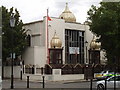
Sikh temple, Queensdale Road, Hammersmith
The Central Gurdwara (Kalsa Jatha) London http://www.centralgurdwara.org.uk/ was founded in 1908 and moved to this site on the corner of Queensdale and Norland roads in 1969. The domes were added in the 1990s.
Image: © David Hawgood
Taken: 21 Aug 2008
0.05 miles
6
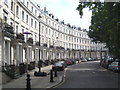
The Royal Crescent Holland Park
Designed in 1839 by Robert Cantwell and Grade II* Listed.
Image: © Rod Allday
Taken: 19 Aug 2012
0.05 miles
7
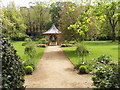
Garden square of Royal Crescent, Kensington
This garden is between Royal Crescent and Holland Park Avenue. It is a private garden available to residents of houses in the crescent; they pay for its upkeep through an addition to their council tax. Like many garden squares in the area, it is regulated under the Kensington Improvement Act 1851.
Image: © David Hawgood
Taken: 3 May 2008
0.05 miles
8
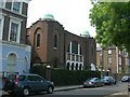
Spanish & Portuguese Synagogue, St. James's Gardens, W11
Address is 8 St. James's Gardens, London W11 4RB
Image: © Danny P Robinson
Taken: 29 Apr 2007
0.05 miles
10
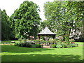
Royal Crescent Gardens, gazebo and plane trees
The central gazebo has been installed in 2007; two large plane trees date at least from 1840 when the crescent was built.
Image: © David Hawgood
Taken: 19 Jun 2016
0.06 miles