IMAGES TAKEN NEAR TO
Darnley Terrace, LONDON, W11 4RL
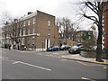
Introduction
This page details the photographs taken nearby to Darnley Terrace, W11 4RL by members of the Geograph project.
The Geograph project started in 2005 with the aim of publishing, organising and preserving representative images for every square kilometre of Great Britain, Ireland and the Isle of Man.

There are currently over 7.5m images from over14,400 individuals and you can help contribute to the project by visiting https://www.geograph.org.uk
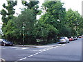
Image Map
Images are licensed for reuse under creativecommons.org/licenses/by-sa/2.0
Notes
- Clicking on the map will re-center to the selected point.
- The higher the marker number, the further away the image location is from the centre of the postcode.
Image Listing (218 Images Found)
Images are licensed for reuse under creativecommons.org/licenses/by-sa/2.0
Image
Details
Distance
1
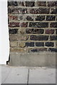
Benchmark on #16 St Anns Road
Ordnance Survey cut mark benchmark described on the Bench Mark Database at http://www.bench-marks.org.uk/bm41930
Image: © Roger Templeman
Taken: 10 Mar 2012
0.02 miles
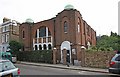
2
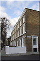
Houses of St Anns Road at Darnley Terrace junction
There is an OS benchmark Image on the house wall below the road name sign
Image: © Roger Templeman
Taken: 10 Mar 2012
0.02 miles
3
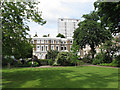
St James's Gardens, Norland Estate
The church of St James Norlands is in the centre of this garden, laid out with surrounding terraces of houses in the 1840s.
Image: © David Hawgood
Taken: 19 Jun 2016
0.03 miles
4
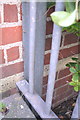
Partially obscured benchmark on #19-24 Dorrit House
Ordnance Survey cut mark benchmark described on the Bench Mark Database at http://www.bench-marks.org.uk/bm41929
Image: © Roger Templeman
Taken: 10 Mar 2012
0.04 miles
5
Flats #19-24 Dorrit House, St Anns Road
There is an OS benchmark Image on the corner of the building where the metal fence is secured to it
Image: © Roger Templeman
Taken: 10 Mar 2012
0.04 miles
6
St. James's Gardens, W11
Another one of the many private squares in the area.
Image: © Phillip Perry
Taken: 25 Jun 2009
0.04 miles
7
Junction of St James Gardens and St Annes's Villas
Image: © Richard Rogerson
Taken: 4 Apr 2013
0.05 miles
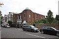
10
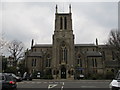
St James Church, Holland Park
The Grade II listed church was built in 1856. The architects were Lewis Vulliamy and Robert Withers.
Image: © Richard Rogerson
Taken: 4 Apr 2013
0.07 miles