IMAGES TAKEN NEAR TO
Christophers Mews, LONDON, W11 4QZ
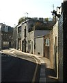
Introduction
This page details the photographs taken nearby to Christophers Mews, W11 4QZ by members of the Geograph project.
The Geograph project started in 2005 with the aim of publishing, organising and preserving representative images for every square kilometre of Great Britain, Ireland and the Isle of Man.

There are currently over 7.5m images from over14,400 individuals and you can help contribute to the project by visiting https://www.geograph.org.uk
Image Map
Images are licensed for reuse under creativecommons.org/licenses/by-sa/2.0
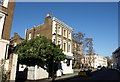
Notes
- Clicking on the map will re-center to the selected point.
- The higher the marker number, the further away the image location is from the centre of the postcode.
Image Listing (180 Images Found)
Images are licensed for reuse under creativecommons.org/licenses/by-sa/2.0
Image
Details
Distance
1
The Academy, Kensington
A gastropub - sorry, bar and restaurant - on the corner of Princedale Road (foreground) and Penzance Street.
Image: © Derek Harper
Taken: 19 Mar 2012
0.04 miles
2
Pottery Lane, Notting Hill
Located on good clay land and used for brick fields in the C18, becoming a notorious and dangerous slum in the mid-C19 http://en.wikipedia.org/wiki/Pottery_Lane ; now a quaint backstreet between Princedale Road and Portland Road.
Image: © Derek Harper
Taken: 19 Mar 2012
0.06 miles
3
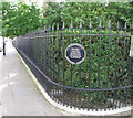
Railings of Norland Square Garden
The plaque reads:
"Norland Square Garden Committee.
These railings were completed in 2007 to replace the original railings which were removed at the beginning of the Second World War.
Susan Walker Architects. The Cast Iron Co Ltd."
Image: © David Hawgood
Taken: 19 Jun 2016
0.07 miles
4
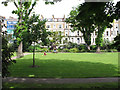
St James's Gardens London W11
The terrace of houses seen beyond the garden was built in the 1860s, whereas most of the terraces round the square were built in the 1840s.
Image: © David Hawgood
Taken: 19 Jun 2016
0.07 miles
5
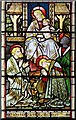
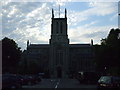
St James, St James's Gardens, Norlands, London W11 - East window detail
Image: © John Salmon
Taken: 17 Oct 2009
0.07 miles
6
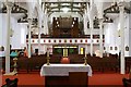
St James, St James's Gardens, Norlands, London W11 - West end
Image: © John Salmon
Taken: 17 Oct 2009
0.07 miles
7
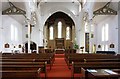
St James, St James's Gardens, Norlands, London W11 - East end
Image: © John Salmon
Taken: 17 Oct 2009
0.07 miles
8
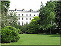
Norland Square terrace and central garden
Norland Square was developed in the 1840s with a central garden available for residents. The garden is surrounded by roads.
Image: © David Hawgood
Taken: 19 Jun 2016
0.08 miles
9
St. James, Norland Square church, W11
Built in 1846, that is its correct title according to other websites, even though it's not in Norland Square the church is located in St. James's Gardens.
Image: © Phillip Perry
Taken: 25 Jun 2009
0.08 miles
10
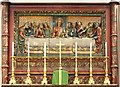
St James, St James's Gardens, Norlands, London W11 - Reredos
Depicting the Last Supper
Image: © John Salmon
Taken: 17 Oct 2009
0.08 miles