IMAGES TAKEN NEAR TO
Addison Avenue, LONDON, W11 4QS
Introduction
This page details the photographs taken nearby to Addison Avenue, W11 4QS by members of the Geograph project.
The Geograph project started in 2005 with the aim of publishing, organising and preserving representative images for every square kilometre of Great Britain, Ireland and the Isle of Man.

There are currently over 7.5m images from over14,400 individuals and you can help contribute to the project by visiting https://www.geograph.org.uk
Image Map
Images are licensed for reuse under creativecommons.org/licenses/by-sa/2.0
Notes
- Clicking on the map will re-center to the selected point.
- The higher the marker number, the further away the image location is from the centre of the postcode.
Image Listing (286 Images Found)
Images are licensed for reuse under creativecommons.org/licenses/by-sa/2.0
Image
Details
Distance
1
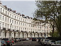
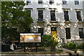
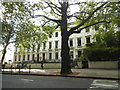
Royal Crescent, Norland Estate, Kensington
This crescent was laid out by Robert Cantwell in 1846 as part of the Norland Estate, to be similar to crescents in Regent's Park and Bath.
Image: © David Hawgood
Taken: 3 May 2008
0.03 miles
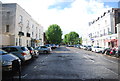
3
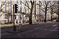
Garage block on Queensdale Road
There is an OS benchmark Image on the right hand face of the right end garage (on the Princes Place face)
Image: © Roger Templeman
Taken: 10 Mar 2012
0.04 miles
4
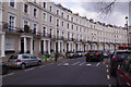
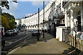
Royal Crescent, Kensington
Inspired by its namesake in Bath this crescent of houses was built in the 1840s to a design by Robert Cantwell. The terrace is grade II listed and overlooks a private communal garden.
Image: © Stephen McKay
Taken: 23 Mar 2019
0.05 miles
7
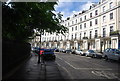
Holland Park Avenue, Kensington
Holland park Avenue is seen here at its junction with Addison Road and Royal crescent showing some of the grand terraces on the north side. The road is part of the A402.
Image: © Stephen McKay
Taken: 24 Mar 2019
0.05 miles
9
Georgian terrace on Holland Park Avenue
Image: © David Howard
Taken: 7 Jun 2014
0.06 miles
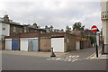
10
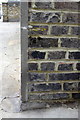
Benchmark on garage block, Queensdale Road
Ordnance Survey cut mark benchmark described on the Bench Mark Database at http://www.bench-marks.org.uk/bm41931
Image: © Roger Templeman
Taken: 10 Mar 2012
0.06 miles