IMAGES TAKEN NEAR TO
Norland Place, LONDON, W11 4QG
Introduction
This page details the photographs taken nearby to Norland Place, W11 4QG by members of the Geograph project.
The Geograph project started in 2005 with the aim of publishing, organising and preserving representative images for every square kilometre of Great Britain, Ireland and the Isle of Man.

There are currently over 7.5m images from over14,400 individuals and you can help contribute to the project by visiting https://www.geograph.org.uk
Image Map
Images are licensed for reuse under creativecommons.org/licenses/by-sa/2.0
Notes
- Clicking on the map will re-center to the selected point.
- The higher the marker number, the further away the image location is from the centre of the postcode.
Image Listing (214 Images Found)
Images are licensed for reuse under creativecommons.org/licenses/by-sa/2.0
Image
Details
Distance
1
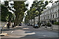
Holland Park Avenue, W11
Shops and plane trees along the north side of the A402.
Image: © Derek Harper
Taken: 19 Mar 2012
0.02 miles
2
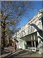
Retailing & Apartment Blocks, Holland Park Road
Image: © Peter Whatley
Taken: 6 Apr 2010
0.02 miles
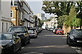
6
Holland Park Avenue, Holland Park junction
Image: © N Chadwick
Taken: 24 May 2014
0.05 miles

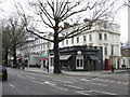
9
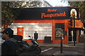
View of Mister Pumpernink pizza restaurant on the corner of Holland Park Avenue and Portland Road
This is probably the closest you'll get to a Halloween-like shop in Notting Hill, not least because the name of the shop is an anagram of "pumpkin". Looking northeast.
Image: © Robert Lamb
Taken: 27 Oct 2019
0.05 miles