IMAGES TAKEN NEAR TO
Mary Place, LONDON, W11 4PW
Introduction
This page details the photographs taken nearby to Mary Place, W11 4PW by members of the Geograph project.
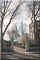
The Geograph project started in 2005 with the aim of publishing, organising and preserving representative images for every square kilometre of Great Britain, Ireland and the Isle of Man.

There are currently over 7.5m images from over14,400 individuals and you can help contribute to the project by visiting https://www.geograph.org.uk
Image Map
Images are licensed for reuse under creativecommons.org/licenses/by-sa/2.0
Notes
- Clicking on the map will re-center to the selected point.
- The higher the marker number, the further away the image location is from the centre of the postcode.
Image Listing (124 Images Found)
Images are licensed for reuse under creativecommons.org/licenses/by-sa/2.0
Image
Details
Distance
1
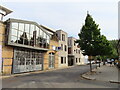
Street frontage of Walmer Courtyard and Walmer Yard
The large window with gate beneath is Walmer Courtyard, small business units. Beyond it, lighter colour, are two of the four houses of Walmer Yard. Photo taken during Open House Festival.
Image: © David Hawgood
Taken: 16 Sep 2023
0.03 miles
2
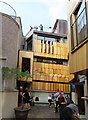
Walmer Yard Open House, courtyard and house 2
The Open House Festival https://programme.openhouse.org.uk/listings/189 tells us:
"Forming a discreet and private set of four interlocking houses set around an open courtyard, Walmer Yard is Peter Salter's only UK project. The houses now form the home of the Baylight Foundation."
Image: © David Hawgood
Taken: 16 Sep 2023
0.03 miles
3
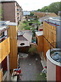
Walmer Yard Open House, view to Winterbourne House
Winterbourne House is the tall block on the left. For a description see the Wikipedia entry for Portland Road https://en.wikipedia.org/wiki/Portland_Road,_Notting_Hill which describes it as built after slum clearance. Houses on the right are in Walmer Road.
Image: © David Hawgood
Taken: 16 Sep 2023
0.03 miles
4
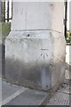
Benchmark on Avondale Park gatepost
Ordnance Survey cut mark benchmark described on the Bench Mark Database at http://www.bench-marks.org.uk/bm41928
Image: © Roger Templeman
Taken: 10 Mar 2012
0.04 miles
5
Walner Road entrance to Avondale Park
There is an OS benchmark Image on the left hand side gatepost
Image: © Roger Templeman
Taken: 10 Mar 2012
0.04 miles
6
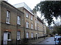
Block of flats in Runcorn Place, London
Image: © PAUL FARMER
Taken: 27 Oct 2011
0.04 miles
7
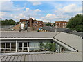
Roof of Walmer Courtyard, view from Walmer Yard
Walmer Courtyard is a set of small business units, offices and studios. Photo from roof during open day.
Image: © David Hawgood
Taken: 16 Sep 2023
0.04 miles
8
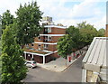
Walmer Yard Open House, rooftop view to Eastry House
Eastry House is Walmer Road Health Centre. The view includes the top of Grenfell Tower.
Image: © David Hawgood
Taken: 16 Sep 2023
0.04 miles
9
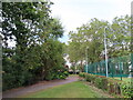
Avondale Park, Kensington
Tennis courts on the right of photo.
Image: © David Hawgood
Taken: 16 Sep 2023
0.05 miles
10

Avondale Park
A corner of the small urban park.
Image: © Robin Webster
Taken: 27 Mar 2011
0.05 miles