IMAGES TAKEN NEAR TO
Norland Square, LONDON, W11 4PU
Introduction
This page details the photographs taken nearby to Norland Square, W11 4PU by members of the Geograph project.
The Geograph project started in 2005 with the aim of publishing, organising and preserving representative images for every square kilometre of Great Britain, Ireland and the Isle of Man.

There are currently over 7.5m images from over14,400 individuals and you can help contribute to the project by visiting https://www.geograph.org.uk
Image Map
Images are licensed for reuse under creativecommons.org/licenses/by-sa/2.0
Notes
- Clicking on the map will re-center to the selected point.
- The higher the marker number, the further away the image location is from the centre of the postcode.
Image Listing (193 Images Found)
Images are licensed for reuse under creativecommons.org/licenses/by-sa/2.0
Image
Details
Distance
1
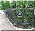
Railings of Norland Square Garden
The plaque reads:
"Norland Square Garden Committee.
These railings were completed in 2007 to replace the original railings which were removed at the beginning of the Second World War.
Susan Walker Architects. The Cast Iron Co Ltd."
Image: © David Hawgood
Taken: 19 Jun 2016
0.02 miles
2
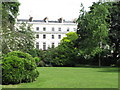
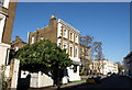
Norland Square terrace and central garden
Norland Square was developed in the 1840s with a central garden available for residents. The garden is surrounded by roads.
Image: © David Hawgood
Taken: 19 Jun 2016
0.03 miles
3
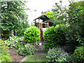
Playhouse in Norland Square Gardens
The communal gardens in residential squares provide safe playing areas for children living in the terraces around the squares.
Image: © David Hawgood
Taken: 19 Jun 2016
0.03 miles
4
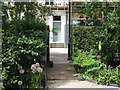
Gate to Norland Square Gardens
This gate opposite No. 48 Norland Square is normally locked; residents of the square have keys. This photo with it unlocked was taken during Open Garden Squares weekend. The flowers with purple globes on stalks are alliums.
Image: © David Hawgood
Taken: 19 Jun 2016
0.06 miles
5
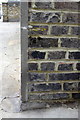
Benchmark on garage block, Queensdale Road
Ordnance Survey cut mark benchmark described on the Bench Mark Database at http://www.bench-marks.org.uk/bm41931
Image: © Roger Templeman
Taken: 10 Mar 2012
0.06 miles
6
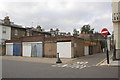
Garage block on Queensdale Road
There is an OS benchmark Image on the right hand face of the right end garage (on the Princes Place face)
Image: © Roger Templeman
Taken: 10 Mar 2012
0.07 miles
7
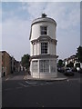
The Academy, Kensington
A gastropub - sorry, bar and restaurant - on the corner of Princedale Road (foreground) and Penzance Street.
Image: © Derek Harper
Taken: 19 Mar 2012
0.08 miles

9
Junction of Pottery Lane and Portland Road W11
Image: © Robin Sones
Taken: 27 Aug 2016
0.09 miles
10
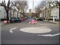
Road closure
Addison Avenue leading to St James's Church Norlands.
Image: © Peter Holmes
Taken: 4 Mar 2009
0.09 miles