IMAGES TAKEN NEAR TO
Clarendon Road, LONDON, W11 4JB
Introduction
This page details the photographs taken nearby to Clarendon Road, W11 4JB by members of the Geograph project.
The Geograph project started in 2005 with the aim of publishing, organising and preserving representative images for every square kilometre of Great Britain, Ireland and the Isle of Man.

There are currently over 7.5m images from over14,400 individuals and you can help contribute to the project by visiting https://www.geograph.org.uk
Image Map
Images are licensed for reuse under creativecommons.org/licenses/by-sa/2.0
Notes
- Clicking on the map will re-center to the selected point.
- The higher the marker number, the further away the image location is from the centre of the postcode.
Image Listing (222 Images Found)
Images are licensed for reuse under creativecommons.org/licenses/by-sa/2.0
Image
Details
Distance
2
Junction of Pottery Lane and Portland Road W11
Image: © Robin Sones
Taken: 27 Aug 2016
0.04 miles
3
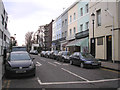
Holland Park: Clarendon Road
Looking north from its junction with Holland Park Avenue
Image: © Dr Neil Clifton
Taken: 10 Feb 2015
0.06 miles
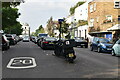
4
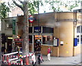
Holland Park station, W11
Taken from the top deck of a 148 bus, Holland Park station, Holland Park Avenue, W11.
Image: © Phillip Perry
Taken: 12 Jun 2008
0.07 miles
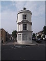
5
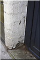
Remains of benchmark at #1 Claredon Road
Ordnance Survey cut mark benchmark described on the Bench Mark Database at http://www.bench-marks.org.uk/bm41829
Image: © Roger Templeman
Taken: 10 Mar 2012
0.07 miles
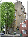
6
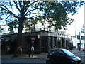
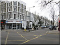
The Castle, Holland Park Avenue W11
At the junction with Clarendon Road
Image: © Robin Sones
Taken: 7 Sep 2010
0.07 miles
7
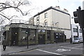
The Castle pub and #1 Clarendon Road
This is the junction of Clarendon Road and Holland Park Avenue. There is an OS benchmark Image by the black gate between the pub and the house.
Image: © Roger Templeman
Taken: 10 Mar 2012
0.07 miles
9
Lansdowne House, Lansdowne Road, W11
A block of flats on the corner of Boyne Terrace Mews. Click here to see the blue plaque in more detail Image
Image: © Danny P Robinson
Taken: 6 May 2007
0.08 miles
10
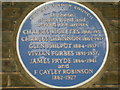
Blue Plaque on Lansdowne House
Click here for picture of entire building. Image
Image: © Danny P Robinson
Taken: 6 May 2007
0.08 miles