IMAGES TAKEN NEAR TO
Olaf Street, LONDON, W11 4BE
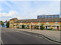
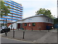
Introduction
This page details the photographs taken nearby to Olaf Street, W11 4BE by members of the Geograph project.
The Geograph project started in 2005 with the aim of publishing, organising and preserving representative images for every square kilometre of Great Britain, Ireland and the Isle of Man.

There are currently over 7.5m images from over14,400 individuals and you can help contribute to the project by visiting https://www.geograph.org.uk
Image Map
Images are licensed for reuse under creativecommons.org/licenses/by-sa/2.0
Notes
- Clicking on the map will re-center to the selected point.
- The higher the marker number, the further away the image location is from the centre of the postcode.
Image Listing (166 Images Found)
Images are licensed for reuse under creativecommons.org/licenses/by-sa/2.0
Image
Details
Distance
1
Terrace housing, Hunt Close, Kensington and Chelsea
Just by the boundary to Hammersmith and Fulham.
Image: © David Hawgood
Taken: 16 Sep 2023
0.03 miles
2
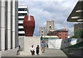
A New Yard To Sit In
In amongst the new buildings in this area which is still partly under construction.
Image: © Des Blenkinsopp
Taken: 30 Jul 2015
0.04 miles
3

Monsoon Accessorize
One of the many new developments in the regeneration of this whole area.
Image: © Des Blenkinsopp
Taken: 30 Jul 2015
0.05 miles
4
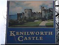
Kenilworth Castle Pub Sign
On Image on St Ann's Road.
Image: © David Anstiss
Taken: 6 Dec 2013
0.05 miles
5

Kenilworth Castle Public House
On the junction on Stoneleigh Road (on the left) and St Anns Road.
Named after https://en.wikipedia.org/wiki/Kenilworth_Castle in Warwickshire.
Image: © David Anstiss
Taken: 6 Dec 2013
0.06 miles
6
Dorrit House, St Anns Road
In 1973 the Ordnance Survey levelled a cut mark benchmark at 7.08m above Newlyn Datum on the facing corner. It is probably still there, but hidden from public view behind the wooden fence.
Image: © Roger Templeman
Taken: 10 Mar 2012
0.08 miles
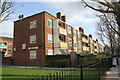
7
Residents Club Room, Henry Dickens Court, Kensington
Henry Dickens Court with a dozen blocks of flats was built by the Council on a bomb site as part of the borough's post war redevelopment plan.
Image: © David Hawgood
Taken: 16 Sep 2023
0.08 miles
8

A3220 Approaching the Westfield London Site
Heading south on the A3220 (was once the M41). This is the site for a new Shopping Centre, to be called Westfield London.
This could not usually be photographed easily as there are no overbridges anywhere along here that a pedestrian can use, and pedestrians and cycles are not permitted on the road itself. This photo was done from the top deck of a number 220 bus which was on diversion from its normal route along Wood Lane.
Image: © Danny P Robinson
Taken: 6 May 2007
0.08 miles
9

Steps from Hunt Close to cross to Westfield
The steps go up to pavements beside slip roads across the West Cross Route.
Image: © David Hawgood
Taken: 16 Sep 2023
0.08 miles
10
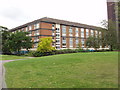
Maisonettes, Edward Woods estate, Hammersmith
The maisonettes with garages underneath are Mortimer House, part of the 1960s Edward Woods Estate designed by Hammersmith Borough Architect's department. Part of the 21 storey Poynter House is on the right. The estate has areas of lawn and trees between the buildings.
Image: © David Hawgood
Taken: 21 Aug 2008
0.09 miles