IMAGES TAKEN NEAR TO
Evesham Street, LONDON, W11 4AR
Introduction
This page details the photographs taken nearby to Evesham Street, W11 4AR by members of the Geograph project.
The Geograph project started in 2005 with the aim of publishing, organising and preserving representative images for every square kilometre of Great Britain, Ireland and the Isle of Man.

There are currently over 7.5m images from over14,400 individuals and you can help contribute to the project by visiting https://www.geograph.org.uk
Image Map
Images are licensed for reuse under creativecommons.org/licenses/by-sa/2.0
Notes
- Clicking on the map will re-center to the selected point.
- The higher the marker number, the further away the image location is from the centre of the postcode.
Image Listing (194 Images Found)
Images are licensed for reuse under creativecommons.org/licenses/by-sa/2.0
Image
Details
Distance
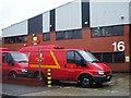
1

Red Boris Bikes
Following a change of sponsorship, London's hire bikes have changed colour.
Image
That must have cost a lot of money, but I expect they go faster now.....
Image: © Des Blenkinsopp
Taken: 30 Jul 2015
0.04 miles
2

Barclay Bike Docking Station on Freston Road
A few bikes are here to be hired for the almost all central London scheme.
In the background is the railway bridge carrying the Circle and Hammersmith and City lines between Wood Lane and Ladbroke Grove stations.
Image: © David Anstiss
Taken: 6 Dec 2013
0.05 miles
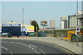
3
West London Line
A freight train on the West London Line north of Shepherd's Bush (overground) station heading underneath the Hammersmith & City Line towards Willesden Junction. Taken from alongside the West Cross Route.
Image: © Phillip Perry
Taken: 30 Oct 2008
0.05 miles
4
Bramley Arms
Former public house on the junction of Freston Road and Bramley Road (on the right). Now housing.
On the left in the background, is the railway bridge carrying the Circle and Hammersmith and City lines between Wood Lane and Ladbroke Grove stations
Image: © David Anstiss
Taken: 6 Dec 2013
0.06 miles
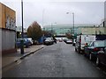
5
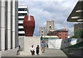
A New Yard To Sit In
In amongst the new buildings in this area which is still partly under construction.
Image: © Des Blenkinsopp
Taken: 30 Jul 2015
0.06 miles
6
Monsoon Accessorize
One of the many new developments in the regeneration of this whole area.
Image: © Des Blenkinsopp
Taken: 30 Jul 2015
0.06 miles
7
W12 & W10 sorting offices, W12
In Silver Road, W12, the sorting offices are arranged over 2 floors one floor for W12 and the other for W10.
Image: © Phillip Perry
Taken: 26 Oct 2008
0.08 miles
8
View from 31 bus on Ariel Way
A route primarily used by buses.
Image: © Robin Webster
Taken: 27 Mar 2011
0.09 miles
9
Silver Road II, W12
Silver Road along with Ariel Way and Relay Road were built in the early 1980's. These few centisquares have changed over the last few months with the construction of the new shopping centre. Looking towards the Westfield shopping centre due to open on Thursday October 30 2008. But will it?????
Image: © Phillip Perry
Taken: 26 Oct 2008
0.09 miles
10
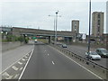
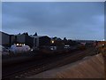
A3220 West Cross Route, White City
This was once designated as the M41. View is heading north towards the Northern Roundabout. The Metropolitan Line crosses over just ahead, and to the left, but out of view, is the line between Kensington Olympia and Willesden Junction.
This is not an easy feature to photograph as there are no overbridges anywhere along here that a pedestrian can use, and pedestrians and cycles are not permitted on the road itself. This photo was done from the top deck of a number 220 bus which was on diversion from its normal route along Wood Lane.
Image: © Danny P Robinson
Taken: 6 May 2007
0.09 miles