IMAGES TAKEN NEAR TO
Holland Park Avenue, LONDON, W11 3QY
Introduction
This page details the photographs taken nearby to Holland Park Avenue, W11 3QY by members of the Geograph project.
The Geograph project started in 2005 with the aim of publishing, organising and preserving representative images for every square kilometre of Great Britain, Ireland and the Isle of Man.

There are currently over 7.5m images from over14,400 individuals and you can help contribute to the project by visiting https://www.geograph.org.uk
Image Map
Images are licensed for reuse under creativecommons.org/licenses/by-sa/2.0
Notes
- Clicking on the map will re-center to the selected point.
- The higher the marker number, the further away the image location is from the centre of the postcode.
Image Listing (226 Images Found)
Images are licensed for reuse under creativecommons.org/licenses/by-sa/2.0
Image
Details
Distance
1
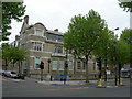
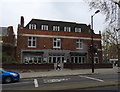
Notting Hill Police Station
On the corner of Ladbroke Grove and Ladbroke Road.
Image: © Danny P Robinson
Taken: 6 May 2007
0.02 miles
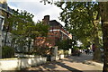
3
On Holland Park Avenue
Near its junction with Ladbroke Grove
Image: © Neil Theasby
Taken: 10 Oct 2021
0.02 miles
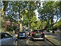
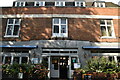
5
The Mitre, Holland Park
On Holland Park Avenue W11.
Image: © JThomas
Taken: 13 Apr 2019
0.02 miles
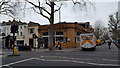
7
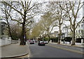
Holland Park Avenue, Holland Park, London W11
Looking south west on the A402 Roman Road.
Image: © JThomas
Taken: 13 Apr 2019
0.03 miles
8
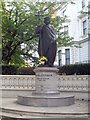
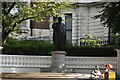
Statue of St Volodymyr in Holland Park Avenue
He was the ruler of Ukraine 980-1015 and the statue was erected by Ukrainians in Great Britain in 1988 to celebrate the establishment of Christianity in Ukraine by St Volodymyr in 988.
Image: © Rod Allday
Taken: 3 Sep 2011
0.03 miles
10
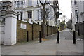
Holland Walk at its junction with Holland Park Avenue
In 1973 the Ordnance Survey verified a cut mark benchmark on the wall by the white corner pier (under the road name sign). The mark was levelled at 18.92m above Newlyn Datum.
Image: © Roger Templeman
Taken: 10 Mar 2012
0.03 miles