IMAGES TAKEN NEAR TO
Ladbroke Road, LONDON, W11 3PJ
Introduction
This page details the photographs taken nearby to Ladbroke Road, W11 3PJ by members of the Geograph project.
The Geograph project started in 2005 with the aim of publishing, organising and preserving representative images for every square kilometre of Great Britain, Ireland and the Isle of Man.

There are currently over 7.5m images from over14,400 individuals and you can help contribute to the project by visiting https://www.geograph.org.uk
Image Map
Images are licensed for reuse under creativecommons.org/licenses/by-sa/2.0
Notes
- Clicking on the map will re-center to the selected point.
- The higher the marker number, the further away the image location is from the centre of the postcode.
Image Listing (339 Images Found)
Images are licensed for reuse under creativecommons.org/licenses/by-sa/2.0
Image
Details
Distance
1
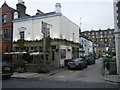
The Ladbroke Arms
Public house in Ladbroke Road.
Image: © Colin Pyle
Taken: 19 Oct 2009
0.04 miles
3
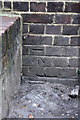
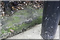
Benchmark on #24 Ladbroke Road
Ordnance Survey cut mark benchmark described on the Bench Mark Database at http://www.bench-marks.org.uk/bm41802
Image: © Roger Templeman
Taken: 10 Mar 2012
0.04 miles
4
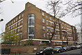
Bowden Court hostel, #24 Ladbroke Road
There is an OS benchmark Image on the Ladbroke Terrace face of the hostel
Image: © Roger Templeman
Taken: 10 Mar 2012
0.04 miles
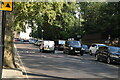
5

Ladbroke Grove, W11
Taken from the top deck of a 148 bus, junction with Holland Park Avenue.
Image: © Phillip Perry
Taken: 12 Jun 2008
0.05 miles
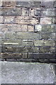
6
Benchmark on low wall of Hillsleigh Road
Ordnance Survey rivet benchmark described on the Bench Mark Database at http://www.bench-marks.org.uk/bm41922
Image: © Roger Templeman
Taken: 10 Mar 2012
0.06 miles
7
Junction of Hillsleigh Road and Holland Park Avenue
There is an OS benchmark Image on top of the very low wall under the Hillsleigh Road road name sign
Image: © Roger Templeman
Taken: 10 Mar 2012
0.06 miles
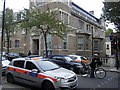
9
Benchmark on Notting Hill Police Station
Ordnance Survey cut mark benchmark described on the Bench Mark Database at http://www.bench-marks.org.uk/bm41824
Image: © Roger Templeman
Taken: 10 Mar 2012
0.06 miles
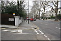
10
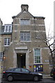
Notting Hall Police Station, Ladbroke Road
There is an OS benchmark Image on the wall below the Ladbroke Road sign
Image: © Roger Templeman
Taken: 10 Mar 2012
0.06 miles