IMAGES TAKEN NEAR TO
Ladbroke Road, LONDON, W11 3NT
Introduction
This page details the photographs taken nearby to Ladbroke Road, W11 3NT by members of the Geograph project.
The Geograph project started in 2005 with the aim of publishing, organising and preserving representative images for every square kilometre of Great Britain, Ireland and the Isle of Man.

There are currently over 7.5m images from over14,400 individuals and you can help contribute to the project by visiting https://www.geograph.org.uk
Image Map
Images are licensed for reuse under creativecommons.org/licenses/by-sa/2.0
Notes
- Clicking on the map will re-center to the selected point.
- The higher the marker number, the further away the image location is from the centre of the postcode.
Image Listing (200 Images Found)
Images are licensed for reuse under creativecommons.org/licenses/by-sa/2.0
Image
Details
Distance
1
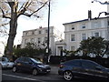
Houses on Ladbroke Grove, Notting Hill
Image: © David Howard
Taken: 12 Apr 2014
0.03 miles
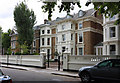
2
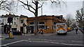
Ladbroke Road and Lansdowne Road junction
Image: © John Salmon
Taken: 26 May 2011
0.04 miles
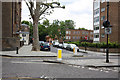
5
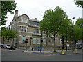
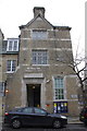
Notting Hill Police Station
On the corner of Ladbroke Grove and Ladbroke Road.
Image: © Danny P Robinson
Taken: 6 May 2007
0.05 miles
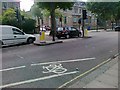
7
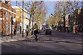
Ladbroke Grove
Seen here at its southern end, Ladbroke Grove stretches through Notting Hill and North Kensington eventually to Harrow Road. Perhaps because it is referenced in Van Morrison's much-loved album 'Astral Weeks', it has something of an iconic status - or maybe it is remembered for the serious rail crash of 1999. The name derives from Richard Ladbrooke (sic) who owned land here in the 17th century and whose family sold it for house building in 1845. There is not much traffic in this sunny Sunday morning view although a cyclist hurries past along Holland Park Avenue.
Image: © Stephen McKay
Taken: 24 Mar 2019
0.07 miles
8
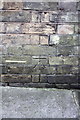
Benchmark on Notting Hill Police Station
Ordnance Survey cut mark benchmark described on the Bench Mark Database at http://www.bench-marks.org.uk/bm41824
Image: © Roger Templeman
Taken: 10 Mar 2012
0.07 miles
9
Notting Hall Police Station, Ladbroke Road
There is an OS benchmark Image on the wall below the Ladbroke Road sign
Image: © Roger Templeman
Taken: 10 Mar 2012
0.07 miles
10
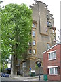
Lansdowne House, Lansdowne Road, W11
A block of flats on the corner of Boyne Terrace Mews. Click here to see the blue plaque in more detail Image
Image: © Danny P Robinson
Taken: 6 May 2007
0.07 miles