IMAGES TAKEN NEAR TO
Lansdowne Walk, LONDON, W11 3AW
Introduction
This page details the photographs taken nearby to Lansdowne Walk, W11 3AW by members of the Geograph project.
The Geograph project started in 2005 with the aim of publishing, organising and preserving representative images for every square kilometre of Great Britain, Ireland and the Isle of Man.

There are currently over 7.5m images from over14,400 individuals and you can help contribute to the project by visiting https://www.geograph.org.uk
Image Map
Images are licensed for reuse under creativecommons.org/licenses/by-sa/2.0
Notes
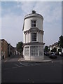
- Clicking on the map will re-center to the selected point.
- The higher the marker number, the further away the image location is from the centre of the postcode.
Image Listing (187 Images Found)
Images are licensed for reuse under creativecommons.org/licenses/by-sa/2.0
Image
Details
Distance
1
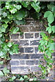
Benchmark on the wall of Lansdowne Walk
Ordnance Survey cut mark benchmark described on the Bench Mark Database at http://www.bench-marks.org.uk/bm38038
Image: © Roger Templeman
Taken: 20 May 2011
0.04 miles
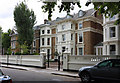
3
Ladbroke Road and Lansdowne Road junction
Image: © John Salmon
Taken: 26 May 2011
0.08 miles
4
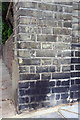
Benchmark on wall angle pier at #32 Lansdowne Road
Ordnance Survey cut mark benchmark described on the Bench Mark Database at http://www.bench-marks.org.uk/bm38036
Image: © Roger Templeman
Taken: 20 May 2011
0.08 miles
5
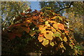
View of autumn leaves on St. John's Gardens
Looking northeast.
Image: © Robert Lamb
Taken: 27 Oct 2019
0.08 miles
6
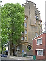
Lansdowne House, Lansdowne Road, W11
A block of flats on the corner of Boyne Terrace Mews. Click here to see the blue plaque in more detail Image
Image: © Danny P Robinson
Taken: 6 May 2007
0.09 miles
7
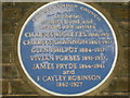
Blue Plaque on Lansdowne House
Click here for picture of entire building. Image
Image: © Danny P Robinson
Taken: 6 May 2007
0.09 miles
8
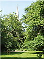
Hanover Gardens with St John's Church
Communal garden for residents of Lansdowne Walk (which used to be called Hanover Terrace hence the name) and other surrounding streets. Photo taken during Open Squares Weekend http://www.opensquares.org/ .
Image: © David Hawgood
Taken: 8 Jun 2008
0.10 miles
9
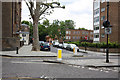
Junction of Pottery Lane and Portland Road W11
Image: © Robin Sones
Taken: 27 Aug 2016
0.11 miles
10
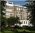
Hillcrest from Hanover Gardens
Hillcrest is a block of flats set back from Ladbroke Grove, and adjacent to these communal gardens.
Image: © David Hawgood
Taken: 8 Jun 2008
0.11 miles