IMAGES TAKEN NEAR TO
Clarendon Road, LONDON, W11 3AA
Introduction
This page details the photographs taken nearby to Clarendon Road, W11 3AA by members of the Geograph project.
The Geograph project started in 2005 with the aim of publishing, organising and preserving representative images for every square kilometre of Great Britain, Ireland and the Isle of Man.

There are currently over 7.5m images from over14,400 individuals and you can help contribute to the project by visiting https://www.geograph.org.uk
Image Map (Loading...)


Getting Data...Please wait
Leaflet Map data © OpenStreetMap
Images are licensed for reuse under creativecommons.org/licenses/by-sa/2.0
Notes
- Clicking on the map will re-center to the selected point.
- The higher the marker number, the further away the image location is from the centre of the postcode.
Image Listing (208 Images Found)
Images are licensed for reuse under creativecommons.org/licenses/by-sa/2.0
Image
Details
Distance
1
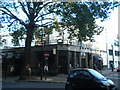
The Castle, Holland Park Avenue W11
At the junction with Clarendon Road
Image: © Robin Sones
Taken: 7 Sep 2010
0.00 miles
2
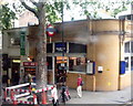
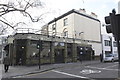
Holland Park station, W11
Taken from the top deck of a 148 bus, Holland Park station, Holland Park Avenue, W11.
Image: © Phillip Perry
Taken: 12 Jun 2008
0.01 miles
3
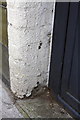
Remains of benchmark at #1 Claredon Road
Ordnance Survey cut mark benchmark described on the Bench Mark Database at http://www.bench-marks.org.uk/bm41829
Image: © Roger Templeman
Taken: 10 Mar 2012
0.01 miles
4
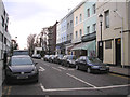
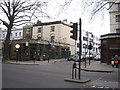
Holland Park: Clarendon Road
Looking north from its junction with Holland Park Avenue
Image: © Dr Neil Clifton
Taken: 10 Feb 2015
0.02 miles
5
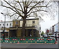
The Castle pub and #1 Clarendon Road
This is the junction of Clarendon Road and Holland Park Avenue. There is an OS benchmark Image by the black gate between the pub and the house.
Image: © Roger Templeman
Taken: 10 Mar 2012
0.02 miles
6
The 'Castle', Holland Park Avenue
Despite its somewhat sombre appearance, this is a decent pub with a useful selection of real ales.
Image: © Dr Neil Clifton
Taken: 10 Feb 2015
0.03 miles
7
The Castle Pub, Holland Park, London
Holland Park Avenue, Holland Park, London W11.
Image: © JThomas
Taken: 13 Apr 2019
0.03 miles
8
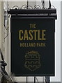
Sign for the Castle Pub, Holland Park, London
Image: © JThomas
Taken: 13 Apr 2019
0.03 miles
9
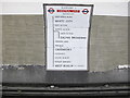
Heritage sign kept at refurbished Holland Park Station
This sign opposite the westbound platform shows the list of stations on the Central Line to Ealing Broadway or West Ruislip. The standard for such signs has progressively been modified to give extra information. See Image for an example with the line coloured in, indications of connections to other tube lines and network rail, etc. In a few places signs in older styles like this are retained. The lifts at this station have just been refurbished and while it was done the walls were stripped. In due course there will be advertising on the wall next to the sign.
Image: © David Hawgood
Taken: 6 Aug 2016
0.04 miles
10
London (Kensington), 1993: Holland Park Avenue
View westward on A402 towards Shepherds Bush at Holland Park station (LT Central Line) on right.
Image: © Ben Brooksbank
Taken: 16 Oct 1993
0.04 miles