IMAGES TAKEN NEAR TO
Lansdowne Road, LONDON, W11 2LG
Introduction
This page details the photographs taken nearby to Lansdowne Road, W11 2LG by members of the Geograph project.
The Geograph project started in 2005 with the aim of publishing, organising and preserving representative images for every square kilometre of Great Britain, Ireland and the Isle of Man.

There are currently over 7.5m images from over14,400 individuals and you can help contribute to the project by visiting https://www.geograph.org.uk
Image Map
Images are licensed for reuse under creativecommons.org/licenses/by-sa/2.0
Notes
- Clicking on the map will re-center to the selected point.
- The higher the marker number, the further away the image location is from the centre of the postcode.
Image Listing (134 Images Found)
Images are licensed for reuse under creativecommons.org/licenses/by-sa/2.0
Image
Details
Distance
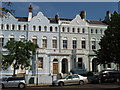
1
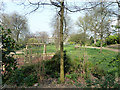
Montpelier Garden, Notting Hill
One of a series of shared private gardens in this area.
Image: © Robin Webster
Taken: 27 Mar 2011
0.03 miles
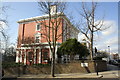
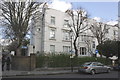
2
Lansdowne Road, W11
Junction with Rosmead Road.
Image: © Des Blenkinsopp
Taken: 15 Mar 2017
0.05 miles
3
Benchmark on the boundary wall of #45 Lansdowne Road
Ordnance Survey cut mark benchmark described on the Bench Mark Database at http://www.bench-marks.org.uk/bm38037
Image: © Roger Templeman
Taken: 20 May 2011
0.05 miles
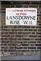
4
View across Lansdowne Rise of #44 Lansdowne Road
There is an OS benchmark Image below the Lansdowne Rise name sign
Image: © Roger Templeman
Taken: 10 Mar 2012
0.05 miles
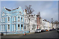
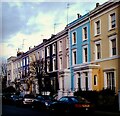
5
Lansdowne Road terrace houses
Part of the Lansdowne Estate, houses built around 1850. Rendering painted in a variety of pastel colours. View from Rosmead Road.
Image: © David Hawgood
Taken: 8 Jun 2008
0.06 miles
7
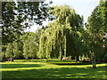
Clarendon Road and Lansdowne Road Communal Garden
Laid out around 1860 for the use of residents of those two roads. Photo taken when it participated in Open Squares Weekend http://www.opensquares.org/ .
Image: © David Hawgood
Taken: 8 Jun 2008
0.07 miles
8
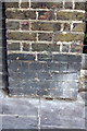
Benchmark on wall pier of #58 Clarendon Road
Ordnance Survey cut mark benchmark described on the Bench Mark Database at http://www.bench-marks.org.uk/bm41830
Image: © Roger Templeman
Taken: 10 Mar 2012
0.09 miles
9
#58 Clarendon Road at junction with Lansdowne Rise
There is an OS benchmark Image on the wall pier at the right end of the curved brick wall
Image: © Roger Templeman
Taken: 10 Mar 2012
0.09 miles
10
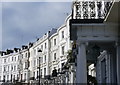
Landsdowne Crescent
Beautiful terrace of white painted houses in Notting Hill.
Image: © Peter Barr
Taken: 23 Feb 2015
0.09 miles