IMAGES TAKEN NEAR TO
Elgin Crescent, LONDON, W11 2JF
Introduction
This page details the photographs taken nearby to Elgin Crescent, W11 2JF by members of the Geograph project.
The Geograph project started in 2005 with the aim of publishing, organising and preserving representative images for every square kilometre of Great Britain, Ireland and the Isle of Man.

There are currently over 7.5m images from over14,400 individuals and you can help contribute to the project by visiting https://www.geograph.org.uk
Image Map (Loading...)


Getting Data...Please wait
Leaflet Map data © OpenStreetMap
Images are licensed for reuse under creativecommons.org/licenses/by-sa/2.0
Notes
- Clicking on the map will re-center to the selected point.
- The higher the marker number, the further away the image location is from the centre of the postcode.
Image Listing (163 Images Found)
Images are licensed for reuse under creativecommons.org/licenses/by-sa/2.0
Image
Details
Distance
1
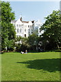
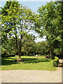
Lansdowne and Elgin Crescent Gardens
Communal garden with local adults relaxing and children playing. Participating in Open Squares Weekend when this photo was taken.
Image: © David Hawgood
Taken: 8 Jun 2008
0.04 miles
2
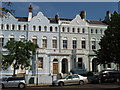
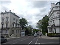
Lansdowne Road terrace houses
Part of the Lansdowne Estate, houses built around 1850. Rendering painted in a variety of pastel colours. View from Rosmead Road.
Image: © David Hawgood
Taken: 8 Jun 2008
0.05 miles
3
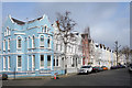
Lansdowne Road, W11
Junction with Rosmead Road.
Image: © Des Blenkinsopp
Taken: 15 Mar 2017
0.05 miles
5
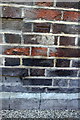
Benchmark on Flat #86 of Nottingwood House
Ordnance Survey cut mark benchmark described on the Bench Mark Database at http://www.bench-marks.org.uk/bm41876
Image: © Roger Templeman
Taken: 10 Mar 2012
0.10 miles
6

Nottingwood House, Clarendon Road
There is an OS benchmark Image on the front left corner of the building which is at the junction with Portland Road
Image: © Roger Templeman
Taken: 10 Mar 2012
0.10 miles
7

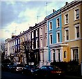
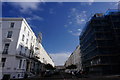
Arundel Gardens London W11
Houses on the north side of Arundel Gardens viewed
from Kensington Park Road looking towards Ladbroke Grove.
The street name sign shows The Royal Borough of Kensington and Chelsea.
Image: © Jaggery
Taken: 13 May 2012
0.10 miles
8
Blenheim and Elgin Crescent Garden
A large communal garden completely hidden from the road behind the houses in both adjacent roads.
Image: © David Hawgood
Taken: 8 Jun 2008
0.10 miles
9
Arundel Gardens
Off Ladbroke Grove, Notting Hill, where it seems like most of London is undergoing restoration or having the basement extended.
Image: © Peter Barr
Taken: 23 Feb 2015
0.11 miles
10
Ladbroke Grove, Notting Hill
Ladbroke Gardens is the road on the right. See https://www.youtube.com/watch?v=rNL4Qy79MpM for a video.
Image: © Hamish Griffin
Taken: 11 May 2018
0.11 miles