IMAGES TAKEN NEAR TO
Wesley Square, LONDON, W11 1TP
Introduction
This page details the photographs taken nearby to Wesley Square, W11 1TP by members of the Geograph project.
The Geograph project started in 2005 with the aim of publishing, organising and preserving representative images for every square kilometre of Great Britain, Ireland and the Isle of Man.

There are currently over 7.5m images from over14,400 individuals and you can help contribute to the project by visiting https://www.geograph.org.uk
Image Map
Images are licensed for reuse under creativecommons.org/licenses/by-sa/2.0
Notes
- Clicking on the map will re-center to the selected point.
- The higher the marker number, the further away the image location is from the centre of the postcode.
Image Listing (157 Images Found)
Images are licensed for reuse under creativecommons.org/licenses/by-sa/2.0
Image
Details
Distance
1
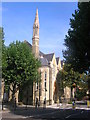
Notting Hill Methodist Church, Silchester Road W10
From across from the junction with Kingsdown Close W10
Image: © Robin Sones
Taken: 8 Sep 2009
0.01 miles
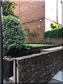
2
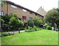
Wesley Square Garden
The houses round this garden were designed by Sir Terry Farrell and completed in 1979, on the site of a council yard.
Image: © David Hawgood
Taken: 19 Jun 2016
0.01 miles
3
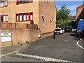
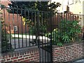
Entrance to Wesley Square from Lancaster Road
Image: © Stuart Taylor
Taken: 7 Aug 2018
0.01 miles
4
Entrance to Wesley Square from Lancaster Road
Image: © Stuart Taylor
Taken: 7 Aug 2018
0.01 miles
5
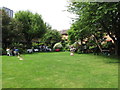
Refreshments on the lawn, Wesley Square
During Open Garden Squares weekend residents served tea, cakes and cocktails.
Image: © David Hawgood
Taken: 19 Jun 2016
0.02 miles
6
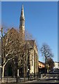
Notting Hill Methodist Church
Another view of Image, looking along Silchester Road.
Image: © Derek Harper
Taken: 19 Mar 2012
0.03 miles
7
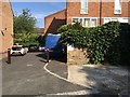
Bartle Road memorial garden
This memorial garden is on the approximate location of no. 10 Rillington Place where John Christie murdered and buried at least eight people in the 1940s and 1950s. The street was renamed Ruston Close in 1954 and finally demolished in 1971 and Bartle Road runs approximately along the same route.
Image: © Stuart Taylor
Taken: 7 Aug 2018
0.03 miles
8
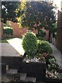
Bartle Road memorial garden
This memorial garden is on the approximate location of no. 10 Rillington Place where John Christie murdered and buried at least eight people in the 1940s and 1950s. The street was renamed Ruston Close in 1954 and finally demolished in 1971 and Bartle Road runs approximately along the same route.
Image: © Stuart Taylor
Taken: 7 Aug 2018
0.03 miles
9
Bartle Road memorial garden, seen from Wesley Square
This memorial garden is on the approximate location of no. 10 Rillington Place where John Christie murdered and buried at least eight people in the 1940s and 1950s. The street was renamed Ruston Close in 1954 and finally demolished in 1971 and Bartle Road runs approximately along the same route.
Image: © Stuart Taylor
Taken: 7 Aug 2018
0.03 miles
10
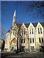
Notting Hill Methodist Church
Seen across Silchester Road, and built in 1879, opening in May 1880 as Lancaster Road Wesleyan Methodist Church http://www.nottinghillmethodistchurch.org/history.htm . Also shown in Image
Image: © Derek Harper
Taken: 19 Mar 2012
0.04 miles