IMAGES TAKEN NEAR TO
Upper Clarendon Walk, LONDON, W11 1SW
Introduction
This page details the photographs taken nearby to Upper Clarendon Walk, W11 1SW by members of the Geograph project.
The Geograph project started in 2005 with the aim of publishing, organising and preserving representative images for every square kilometre of Great Britain, Ireland and the Isle of Man.

There are currently over 7.5m images from over14,400 individuals and you can help contribute to the project by visiting https://www.geograph.org.uk
Image Map
Images are licensed for reuse under creativecommons.org/licenses/by-sa/2.0
Notes
- Clicking on the map will re-center to the selected point.
- The higher the marker number, the further away the image location is from the centre of the postcode.
Image Listing (150 Images Found)
Images are licensed for reuse under creativecommons.org/licenses/by-sa/2.0
Image
Details
Distance
1
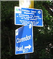
Free Running and jumping prohibited, sign in Kensington
This sign is on a path from Clarendon Road to Lancaster Road through a council-built housing estate. Keeping prohibitions up-to-date with modern pleasure, the notice starts:
Private Land (Residential)
Skateboarding, Free Running or Jumping activities of any kind are strictly prohibited."
Image: © David Hawgood
Taken: 19 Jun 2016
0.03 miles
2
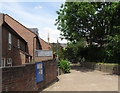
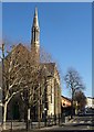
Path from Clarendon Road to Lancaster Road
On this path through a housing estate is the sign Image prohibiting jumping and free running. The spire seen beyond is Notting Hill Methodist Church.
Image: © David Hawgood
Taken: 19 Jun 2016
0.03 miles
3
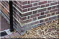
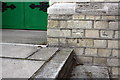
Benchmark on Allom House, Clarendon Road
Ordnance Survey cut mark benchmark described on the Bench Mark Database at http://www.bench-marks.org.uk/bm38089
Image: © Roger Templeman
Taken: 27 May 2011
0.04 miles
4
Notting Hill Methodist Church, Silchester Road W10
From across from the junction with Kingsdown Close W10
Image: © Robin Sones
Taken: 8 Sep 2009
0.07 miles
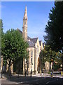
5
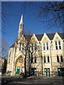
Notting Hill Methodist Church
Seen across Silchester Road, and built in 1879, opening in May 1880 as Lancaster Road Wesleyan Methodist Church http://www.nottinghillmethodistchurch.org/history.htm . Also shown in Image
Image: © Derek Harper
Taken: 19 Mar 2012
0.07 miles
6
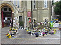
Flowers and candles outside Notting Hill Methodist Church
Notting Hill Methodist Church was one of the focal points for tributes after the horrific Grenfell Tower fire of 14th June 2017. Flowers and candles were much in evidence as well as all the "have you seen?" messages. The whole experience of visiting and reading the messages and tributes is intensely moving and sad.
Image: © Marathon
Taken: 19 Jul 2017
0.07 miles
7
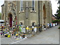
Flowers and tributes outside Notting Hill Methodist Church
Notting Hill Methodist Church was one of the focal points for tributes after the horrific Grenfell Tower fire of 14th June 2017. Flowers and candles were much in evidence as well as all the "have you seen?" messages. The whole experience of visiting and reading the messages and tributes is intensely moving and sad.
Image: © Marathon
Taken: 19 Jul 2017
0.07 miles
8
Notting Hill Methodist Church
Another view of Image, looking along Silchester Road.
Image: © Derek Harper
Taken: 19 Mar 2012
0.07 miles
9
Benchmark on Notting Hill Methodist Church, Kingsdown Close
Ordnance Survey cut mark benchmark described on the Bench Mark Database at http://www.bench-marks.org.uk/bm38094
Image: © Roger Templeman
Taken: 27 May 2011
0.08 miles
10
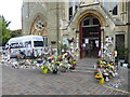
Flowers and candles outside Notting Hill Methodist Church
Notting Hill Methodist Church was one of the focal points for tributes after the horrific Grenfell Tower fire of 14th June 2017. Flowers and candles were much in evidence as well as all the "have you seen?" messages. The whole experience of visiting and reading the messages and tributes is intensely moving and sad.
Image: © Marathon
Taken: 19 Jul 2017
0.08 miles