IMAGES TAKEN NEAR TO
Upper Talbot Walk, LONDON, W11 1QZ
Introduction
This page details the photographs taken nearby to Upper Talbot Walk, W11 1QZ by members of the Geograph project.
The Geograph project started in 2005 with the aim of publishing, organising and preserving representative images for every square kilometre of Great Britain, Ireland and the Isle of Man.

There are currently over 7.5m images from over14,400 individuals and you can help contribute to the project by visiting https://www.geograph.org.uk
Image Map
Images are licensed for reuse under creativecommons.org/licenses/by-sa/2.0
Notes
- Clicking on the map will re-center to the selected point.
- The higher the marker number, the further away the image location is from the centre of the postcode.
Image Listing (139 Images Found)
Images are licensed for reuse under creativecommons.org/licenses/by-sa/2.0
Image
Details
Distance
1
Benchmark on the Virgin Active Health Club, Lancaster Road
Ordnance Survey cut mark benchmark described on the Bench Mark Database at http://www.bench-marks.org.uk/bm38026
Image: © Roger Templeman
Taken: 20 May 2011
0.07 miles
2
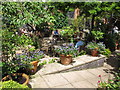
Cafe tables in garden, Museum of Brands
On this visit the garden was open as part of Open Garden Squares weekend, but the cafe is open to visitors until half an hour before the museum closes on other days. See Image for another photo of this garden.
The original planting in 1990 was a donation from the gold-medal-winning Crabtree & Evelyn Chelsea Flower Show scented garden to form part of the London Lighthouse HIV/AIDS centre. The Museum of Brands bought it from London Lighthouse and moved in autumn 2015. See Image for information about the museum.
Image: © David Hawgood
Taken: 19 Jun 2016
0.07 miles
3
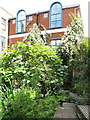
Courtyard garden, Museum of Brands
The original planting in 1990 was a donation from the gold-medal-winning Crabtree & Evelyn Chelsea Flower Show scented garden to form part of the London Lighthouse HIV/AIDS centre. The Museum of Brands bought it from London Lighthouse and moved in autumn 2015. See Image for information about the museum.
Image: © David Hawgood
Taken: 19 Jun 2016
0.07 miles
4
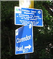
Free Running and jumping prohibited, sign in Kensington
This sign is on a path from Clarendon Road to Lancaster Road through a council-built housing estate. Keeping prohibitions up-to-date with modern pleasure, the notice starts:
Private Land (Residential)
Skateboarding, Free Running or Jumping activities of any kind are strictly prohibited."
Image: © David Hawgood
Taken: 19 Jun 2016
0.08 miles
5
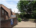
Path from Clarendon Road to Lancaster Road
On this path through a housing estate is the sign Image prohibiting jumping and free running. The spire seen beyond is Notting Hill Methodist Church.
Image: © David Hawgood
Taken: 19 Jun 2016
0.08 miles
6
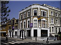
Lancaster House, Lancaster Road
Lancaster House is at the junction of Lancaster Road and St Marks Road
Image: © PAUL FARMER
Taken: 25 May 2010
0.08 miles
7
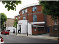
Museum of Brands, Packaging and Advertising
The museum is in the former Bayswater Jewish School, built 1866. It has moved there recently - see Image at its former location in 2008.
Image: © David Hawgood
Taken: 19 Jun 2016
0.09 miles
8
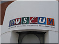
Museum of Brands, logo over doorway
See Image for a photo of the museum and more information.
Image: © David Hawgood
Taken: 19 Jun 2016
0.09 miles
9
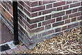
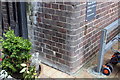
Benchmark on Allom House, Clarendon Road
Ordnance Survey cut mark benchmark described on the Bench Mark Database at http://www.bench-marks.org.uk/bm38089
Image: © Roger Templeman
Taken: 27 May 2011
0.09 miles
10
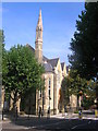
Notting Hill Methodist Church, Silchester Road W10
From across from the junction with Kingsdown Close W10
Image: © Robin Sones
Taken: 8 Sep 2009
0.09 miles