IMAGES TAKEN NEAR TO
Tavistock Crescent, LONDON, W11 1AX
Introduction
This page details the photographs taken nearby to Tavistock Crescent, W11 1AX by members of the Geograph project.
The Geograph project started in 2005 with the aim of publishing, organising and preserving representative images for every square kilometre of Great Britain, Ireland and the Isle of Man.

There are currently over 7.5m images from over14,400 individuals and you can help contribute to the project by visiting https://www.geograph.org.uk
Image Map
Images are licensed for reuse under creativecommons.org/licenses/by-sa/2.0
Notes
- Clicking on the map will re-center to the selected point.
- The higher the marker number, the further away the image location is from the centre of the postcode.
Image Listing (366 Images Found)
Images are licensed for reuse under creativecommons.org/licenses/by-sa/2.0
Image
Details
Distance
1
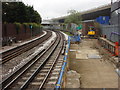
Railway line to the west of Westbourne Park tube station
An elevated section of the A40 'Westway' can be seen on the right
Image: © Oxyman
Taken: 9 Apr 2009
0.06 miles
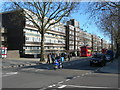
2

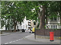
Tavistock Crescent, W11
Shows the location of Image
Image: © Mike Quinn
Taken: 25 Jun 2008
0.06 miles
3

Westbourne Park Station - Looking West
This is the Hammersmith & City line.
Image: © Peter Whatley
Taken: 27 May 2009
0.07 miles
4
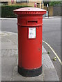
"Anonymous" (Victorian) postbox, Tavistock Road / Tavistock Crescent, W11
The low posting aperture dates this box to 1883-87.
Image: © Mike Quinn
Taken: 25 Jun 2008
0.08 miles
6
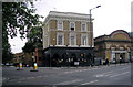
The'Metropolitan', Westbourne Park
At the junction of Tavistock Road with Great Western Road. It amazes me why so many public houses are painted black. I can think of no surer way to deter custom.
Image: © Dr Neil Clifton
Taken: 26 Jul 2008
0.08 miles
7
Great Western Road, W11
Near the junction of Tavistock Road, showing housing on the Brunel Estate.
Image: © Danny P Robinson
Taken: 11 Mar 2007
0.08 miles
8

A very wet Westbourne Park station
Westbourne Park station opened on 1st February 1866 and was served by two existing railway lines – the Hammersmith & City Railway which opened on 13th June 1864 (owned by the Great Western Railway and running between Westbourne Park and Hammersmith stations) and the West London Railway (WLR) opened on 1st July 1864 which left this line at what is now Latimer Road to reach Addison Road (now Kensington Olympia). The link to Addison Road was closed on 19th October 1940. The original Westbourne Park station closed on 31st October 1871 to be replaced the following day by a new station constructed to the east of the original. From October 1871 there were platforms on the adjacent Great Western Main Line at Westbourne Park. These closed in March 1992.
Trains on the Hammersmith & City Line serve the station and now also, in an effort to improve its reliability, the Circle Line. The next station in this direction is Royal Oak. The afternoon was quite as miserable as it looks in the photograph.
Image: © Marathon
Taken: 6 Nov 2013
0.08 miles
9
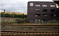
Westbourne Studios from the railway
Westbourne Studios is an office development of approximately 100 work spaces, aimed at young creative businesses serving the Notting Hill area.
Image: © Steve Daniels
Taken: 25 Jun 2012
0.09 miles
