IMAGES TAKEN NEAR TO
Shalfleet Drive, LONDON, W10 6UE
Introduction
This page details the photographs taken nearby to Shalfleet Drive, W10 6UE by members of the Geograph project.
The Geograph project started in 2005 with the aim of publishing, organising and preserving representative images for every square kilometre of Great Britain, Ireland and the Isle of Man.

There are currently over 7.5m images from over14,400 individuals and you can help contribute to the project by visiting https://www.geograph.org.uk
Image Map
Images are licensed for reuse under creativecommons.org/licenses/by-sa/2.0
Notes
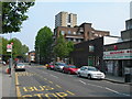
- Clicking on the map will re-center to the selected point.
- The higher the marker number, the further away the image location is from the centre of the postcode.
Image Listing (116 Images Found)
Images are licensed for reuse under creativecommons.org/licenses/by-sa/2.0
Image
Details
Distance
1
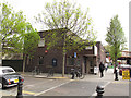
The Pig and Whistle
A pub (of the post-war, single-storey style) on the corner of Bramley Road and Blechynden Street. The pub also appears (unnamed) in Image
Image: © Stephen Craven
Taken: 14 Apr 2012
0.03 miles
2
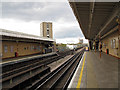
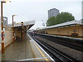
Latimer Road station, looking northeast
An above-ground station on the Hammersmith and City Line of the London Underground. The iron girders between the tracks in the foreground mark the location of the overbridge over Bramley Road. See also Image
Image: © Stephen Craven
Taken: 14 Apr 2012
0.03 miles
3
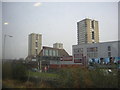
High-rise blocks, from the West London Line
Taken from the train, hence the reflections in the sky. In the foreground the spur road linking Shepherd's Bush roundabout with the Westway.
Image: © Christopher Hilton
Taken: 2 Mar 2012
0.03 miles
4
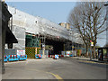
Work on railway over Bramley Road
Latimer Road station, Hammersmith & City Line, straddles the road and is behind the sheeting. Oddly, Latimer Road itself is quite a distance away.
Image: © Robin Webster
Taken: 27 Mar 2011
0.03 miles
5
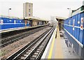
Latimer Road station
Latimer Road station opened on 16th December 1868 at a junction formed between two existing railway lines – the Hammersmith & City Railway opened on 13th June 1864 (owned by the Great Western Railway and running between Westbourne Park and Hammersmith stations) and the West London Railway (WLR) opened on 1st July 1864 to Addison Road (now Kensington Olympia). The link to Addison Road was closed on 19th October 1940 and the junction no longer exists.
Trains on the Hammersmith & City Line serve the station and now also, in an effort to improve its reliability, the Circle Line. The next station in this direction is Ladbroke Grove. The afternoon was quite as miserable as it looks in the photograph.
Image: © Marathon
Taken: 6 Nov 2013
0.03 miles
6
Latimer Road Underground station, London
Opened in 1868 jointly by the Great Western Railway and Metropolitan Railway on what is today the Hammersmith & City underground line.
View north east towards Ladbroke Grove and Paddington, during rebuilding. Like 55% of the London Underground network, this part is actually overground.
Image: © Nigel Thompson
Taken: 22 Jan 2010
0.03 miles
7
Golden Balls at Latimer Road Station
An artistic thingy on top of a new development behind the station.
Image: © Des Blenkinsopp
Taken: 30 Jul 2015
0.04 miles
8
Waynflete Square, W10
This is the Silchester West Estate, and Frinstead House is in the background.
Image: © Danny P Robinson
Taken: 29 Apr 2007
0.04 miles
9
Outside Latimer Road Underground Station (2)
North side of the bridge. Looking along Bramley Road towards the elevated Westway and a tower block on the Silchester Estate. Latimer Road itself is not actually very near the station of the same name though I suspect the building of the nearby A3220 West Cross Route meant much of the road was demolished. A look at the 1940s map shows a very different scene.
Image: © Danny P Robinson
Taken: 29 Apr 2007
0.04 miles
10
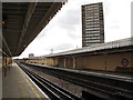
Latimer Road station, looking southwest
An above-ground station on the Hammersmith and City Line of the London Underground. The iron girders between the tracks in the foreground mark the location of the overbridge over Bramley Road. See also Image
Image: © Stephen Craven
Taken: 14 Apr 2012
0.04 miles