IMAGES TAKEN NEAR TO
Bramley Road, LONDON, W10 6TF
Introduction
This page details the photographs taken nearby to Bramley Road, W10 6TF by members of the Geograph project.
The Geograph project started in 2005 with the aim of publishing, organising and preserving representative images for every square kilometre of Great Britain, Ireland and the Isle of Man.

There are currently over 7.5m images from over14,400 individuals and you can help contribute to the project by visiting https://www.geograph.org.uk
Image Map
Images are licensed for reuse under creativecommons.org/licenses/by-sa/2.0
Notes
- Clicking on the map will re-center to the selected point.
- The higher the marker number, the further away the image location is from the centre of the postcode.
Image Listing (126 Images Found)
Images are licensed for reuse under creativecommons.org/licenses/by-sa/2.0
Image
Details
Distance
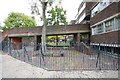
1
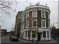
Bramley Arms
Former public house on the junction of Freston Road and Bramley Road (on the right). Now housing.
On the left in the background, is the railway bridge carrying the Circle and Hammersmith and City lines between Wood Lane and Ladbroke Grove stations
Image: © David Anstiss
Taken: 6 Dec 2013
0.02 miles
2

House near St Clement, Treadgold Street, Notting Dale London W11
Image: © John Salmon
Taken: 17 Oct 2009
0.04 miles
3

Barclay Bike Docking Station on Freston Road
A few bikes are here to be hired for the almost all central London scheme.
In the background is the railway bridge carrying the Circle and Hammersmith and City lines between Wood Lane and Ladbroke Grove stations.
Image: © David Anstiss
Taken: 6 Dec 2013
0.04 miles
4

Red Boris Bikes
Following a change of sponsorship, London's hire bikes have changed colour.
Image
That must have cost a lot of money, but I expect they go faster now.....
Image: © Des Blenkinsopp
Taken: 30 Jul 2015
0.04 miles
5

Outside Latimer Road Underground Station (1)
South side of the bridge. Looking across Bramley Road along Hurstway Walk towards Grenfell Tower (both Lancaster West Estate). Latimer Road itself is not actually very near the station of the same name though I suspect the building of the nearby A3220 West Cross Route meant much of the road was demolished. A look at the 1940s map shows a very different scene.
Image: © Danny P Robinson
Taken: 29 Apr 2007
0.06 miles
6
Office, Treadgold Street, Notting Dale London W11
Image: © John Salmon
Taken: 17 Oct 2009
0.06 miles
7
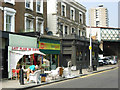
Bramley Road, North Kensington
The second-hand shop has an amusing name, although most of its stock seems to be out on the pavement. The bridge carries the Hammersmith & City Line.
Image: © Stephen McKay
Taken: 3 Apr 2009
0.07 miles
8
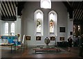
St Clement, Treadgold Street, Notting Dale London W11 - Font
Image: © John Salmon
Taken: 17 Oct 2009
0.07 miles
10

St Clement, Treadgold Street, Notting Dale London W11
Image: © John Salmon
Taken: 17 Oct 2009
0.08 miles