IMAGES TAKEN NEAR TO
Bramley Road, LONDON, W10 6SX
Introduction
This page details the photographs taken nearby to Bramley Road, W10 6SX by members of the Geograph project.
The Geograph project started in 2005 with the aim of publishing, organising and preserving representative images for every square kilometre of Great Britain, Ireland and the Isle of Man.

There are currently over 7.5m images from over14,400 individuals and you can help contribute to the project by visiting https://www.geograph.org.uk
Image Map
Images are licensed for reuse under creativecommons.org/licenses/by-sa/2.0
Notes
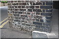
- Clicking on the map will re-center to the selected point.
- The higher the marker number, the further away the image location is from the centre of the postcode.
Image Listing (117 Images Found)
Images are licensed for reuse under creativecommons.org/licenses/by-sa/2.0
Image
Details
Distance
1
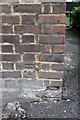
Benchmark on Bramley House, Silchester Road
Ordnance Survey cut mark benchmark described on the Bench Mark Database at http://www.bench-marks.org.uk/bm38104
Image: © Roger Templeman
Taken: 27 May 2011
0.01 miles
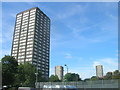
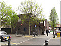
3
Goodrich Court
A housing block on the corner of Bramley Road and Darfield Way.
Image: © Stephen Craven
Taken: 14 Apr 2012
0.04 miles
4
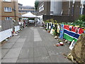
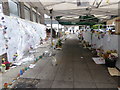
The walls of messages and tributes after the Grenfell Tower fire
The walls of messages were amongst the focal points for tributes after the horrific Grenfell Tower fire of 14th June 2017. Flowers and candles were much in evidence as well as all the "have you seen?" messages. The whole experience of visiting and reading the messages and tributes to the dead and missing, as well as seeing the photographs, is intensely moving and sad. The walls of messages are sheltered from the weather now and are either side of an alleyway leading off Bramley Road, just before reaching Westway flyover. The view from the other end can be seen at http://www.geograph.org.uk/photo/5474662
Image: © Marathon
Taken: 19 Jul 2017
0.04 miles
5
The walls of messages after the Grenfell Tower fire
The walls of messages were amongst the focal points for tributes after the horrific Grenfell Tower fire of 14th June 2017. Flowers and candles were much in evidence as well as all the "have you seen?" messages. The whole experience of visiting and reading the messages and tributes to the dead and missing, as well as seeing the photographs, is intensely moving and sad. The walls of messages are sheltered from the weather now and are either side of an alleyway leading off Bramley Road, just before reaching Westway flyover.
Image: © Marathon
Taken: 19 Jul 2017
0.04 miles
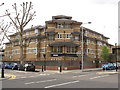
6
The Pig and Whistle
A pub (of the post-war, single-storey style) on the corner of Bramley Road and Blechynden Street. The pub also appears (unnamed) in Image
Image: © Stephen Craven
Taken: 14 Apr 2012
0.04 miles
7
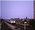
London Underground train approaching Latimer Road
Despite being called London Underground, large parts of the network are above ground. This image was taken from the platform at Latimer Road station as a train approaches.
Image: © Malc McDonald
Taken: 25 Aug 1984
0.05 miles
8
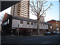
Latymer Christian Centre
This evangelical church is on Bramley Road, almost under the Westway viaduct. The name is presumably taken from nearby Latimer Road station, but spelt differently. There is a bus stop outside, serving routes 316 (Cricklewood to White City) and 295 (Ladbroke Grove to Clapham Junction).
Image: © Stephen Craven
Taken: 14 Apr 2012
0.05 miles
9
Benchmark on railway bridge arch on Silchester Road
Ordnance Survey cut mark benchmark described on the Bench Mark Database at http://www.bench-marks.org.uk/bm38103
Image: © Roger Templeman
Taken: 27 May 2011
0.05 miles
10
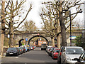
Railway viaduct over Silchester Road
The viaduct carries the Hammersmith and City Line of London Underground. The main arch carries a height restriction of 16ft 6in (5.0m). There are narrow pedestrian arches either side of the main arch; standard size arches either side of the road are used by motor vehicle repairers. Recently pollarded plane trees line the road.
Image: © Stephen Craven
Taken: 14 Apr 2012
0.05 miles