IMAGES TAKEN NEAR TO
Kingsdown Close, LONDON, W10 6SW
Introduction
This page details the photographs taken nearby to Kingsdown Close, W10 6SW by members of the Geograph project.
The Geograph project started in 2005 with the aim of publishing, organising and preserving representative images for every square kilometre of Great Britain, Ireland and the Isle of Man.

There are currently over 7.5m images from over14,400 individuals and you can help contribute to the project by visiting https://www.geograph.org.uk
Image Map
Images are licensed for reuse under creativecommons.org/licenses/by-sa/2.0
Notes
- Clicking on the map will re-center to the selected point.
- The higher the marker number, the further away the image location is from the centre of the postcode.
Image Listing (135 Images Found)
Images are licensed for reuse under creativecommons.org/licenses/by-sa/2.0
Image
Details
Distance
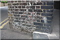
1
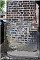
Benchmark on arch of railway bridge over Kingsdown Close
Ordnance Survey cut mark benchmark described on the Bench Mark Database at http://www.bench-marks.org.uk/bm38101
Image: © Roger Templeman
Taken: 27 May 2011
0.01 miles
2
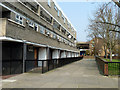
Path, Silchester Estate, W10
Leading off Silchester Road. Westway, the elevated section of the A40, is visible between the buildings.
Image: © Robin Webster
Taken: 27 Mar 2011
0.04 miles
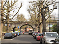
3
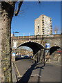
Railway bridge, Silchester Road, W10
Carrying the Circle and Hammersmith & City lines between Latimer Road and Ladbroke Grove stations. Rearing above the parapet is the 20-storey Whitstable House, built in 1966.
Image: © Derek Harper
Taken: 19 Mar 2012
0.04 miles
5
Benchmark on railway bridge arch on Silchester Road
Ordnance Survey cut mark benchmark described on the Bench Mark Database at http://www.bench-marks.org.uk/bm38103
Image: © Roger Templeman
Taken: 27 May 2011
0.05 miles
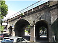
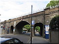
6
Railway viaduct over Silchester Road
The viaduct carries the Hammersmith and City Line of London Underground. The main arch carries a height restriction of 16ft 6in (5.0m). There are narrow pedestrian arches either side of the main arch; standard size arches either side of the road are used by motor vehicle repairers. Recently pollarded plane trees line the road.
Image: © Stephen Craven
Taken: 14 Apr 2012
0.05 miles
7
LUL Bridge over Silchester Road
The bridge carries the Circle and Hammersmith & City lines between Latimer Road and Ladbrooke Grove Stations.
Image: © Richard Rogerson
Taken: 29 Jul 2015
0.05 miles
8
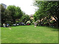
Refreshments on the lawn, Wesley Square
During Open Garden Squares weekend residents served tea, cakes and cocktails.
Image: © David Hawgood
Taken: 19 Jun 2016
0.05 miles
9
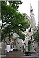
Notting Hill Methodist Church, Kingsdown Close
There is an OS benchmark Image to right of green doors.
Image: © Roger Templeman
Taken: 27 May 2011
0.05 miles
10
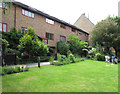
Wesley Square Garden
The houses round this garden were designed by Sir Terry Farrell and completed in 1979, on the site of a council yard.
Image: © David Hawgood
Taken: 19 Jun 2016
0.06 miles