IMAGES TAKEN NEAR TO
Stable Way, LONDON, W10 6QX
Introduction
This page details the photographs taken nearby to Stable Way, W10 6QX by members of the Geograph project.
The Geograph project started in 2005 with the aim of publishing, organising and preserving representative images for every square kilometre of Great Britain, Ireland and the Isle of Man.

There are currently over 7.5m images from over14,400 individuals and you can help contribute to the project by visiting https://www.geograph.org.uk
Image Map
Images are licensed for reuse under creativecommons.org/licenses/by-sa/2.0
Notes
- Clicking on the map will re-center to the selected point.
- The higher the marker number, the further away the image location is from the centre of the postcode.
Image Listing (135 Images Found)
Images are licensed for reuse under creativecommons.org/licenses/by-sa/2.0
Image
Details
Distance
1
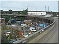
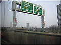
Approaching the Northern Roundabout on the A3220
Showing the A40 Westway Flyover on the horizon and a scrapyard below.
This combination of features is not easy to photograph as there are no overbridges anywhere along here that a pedestrian can use, and pedestrians and cycles are not permitted on the road itself. This photo was done from the top deck of a number 220 bus which was on diversion from its normal route along Wood Lane. (The slight yellow tinge at the bottom of the picture is a reflection from the yellow handrail on the front window)
Image: © Danny P Robinson
Taken: 6 May 2007
0.04 miles
2
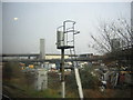
Travellers' site under the Westway, from the West London Line
This travellers' site has been here for many years, despite the residents' concern over levels of pollution from the heavy traffic around them.
Image: © Christopher Hilton
Taken: 2 Mar 2012
0.04 miles
3
Travellers' site under the Westway, from the West London Line
This travellers' site has been here for many years, despite the residents' concern about high levels of pollution from the heavy traffic around them.
Taken from the train, hence the reflection in the sky top left.
Image: © Christopher Hilton
Taken: 2 Mar 2012
0.05 miles
4
A3220 and a Mobile Home Site Below
Just after the Northern Roundabout and heading south.
This combination of features is not easy to photograph as there are no overbridges anywhere along here that a pedestrian can use, and pedestrians and cycles are not permitted on the road itself. This photo was done from the top deck of a number 220 bus which was on diversion from its normal route along Wood Lane. (The slight yellow tinge at the bottom of the picture is a reflection from the yellow handrail on the front window)
Image: © Danny P Robinson
Taken: 6 May 2007
0.05 miles
5
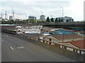
Approaching the Westway, from the West London Line
Traffic here climbs towards the elevated roundabout giving access to the elevated A40 Westway into London or the A40 Western Avenue towards Oxford.
Image: © Christopher Hilton
Taken: 2 Mar 2012
0.06 miles
6
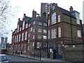
Latimer Education Centre
On Freston Road.
Formerly Thomas Jones Primary School (as named in the listing details). The new Thomas Jones school is on St Marks Road in Image
A Grade II listed building. See http://www.britishlistedbuildings.co.uk/en-201779 for more details about the school building.
Image: © David Anstiss
Taken: 6 Dec 2013
0.06 miles
7
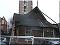
Former Thomas Jones Primary School. School Room
Grade II listed building beside the main (former) Thomas Jones Primary School https://www.geograph.org.uk/photo/3772994 (on the left). See http://www.britishlistedbuildings.co.uk/en-201780 for more details.
Markland House is in the background.
The new school is at Image
Image: © David Anstiss
Taken: 6 Dec 2013
0.08 miles
8
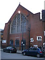
Harrow Club
Former Holy Trinity Church on Freston Road.
Grade II listed. See http://www.britishlistedbuildings.co.uk/en-201777-harrow-club-greater-london-authority for more details about the church.
Image: © David Anstiss
Taken: 6 Dec 2013
0.08 miles
9
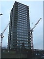
Frinstead House
As seen from Shalfleet Drive. Around it are construction works.
Image: © David Anstiss
Taken: 6 Dec 2013
0.09 miles
10
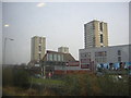
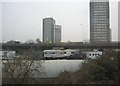
High-rise blocks, from the West London Line
Taken from the train, hence the reflections in the sky. In the foreground the spur road linking Shepherd's Bush roundabout with the Westway.
Image: © Christopher Hilton
Taken: 2 Mar 2012
0.10 miles