IMAGES TAKEN NEAR TO
Latimer Road, LONDON, W10 6QW
Introduction
This page details the photographs taken nearby to Latimer Road, W10 6QW by members of the Geograph project.
The Geograph project started in 2005 with the aim of publishing, organising and preserving representative images for every square kilometre of Great Britain, Ireland and the Isle of Man.

There are currently over 7.5m images from over14,400 individuals and you can help contribute to the project by visiting https://www.geograph.org.uk
Image Map
Images are licensed for reuse under creativecommons.org/licenses/by-sa/2.0
Notes
- Clicking on the map will re-center to the selected point.
- The higher the marker number, the further away the image location is from the centre of the postcode.
Image Listing (58 Images Found)
Images are licensed for reuse under creativecommons.org/licenses/by-sa/2.0
Image
Details
Distance
1
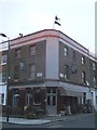
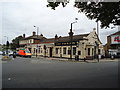
Former Public House (British Volunteer)
On the junction of Latimer Road and Latimer Place (on the right).
Now a Greek restaurant.
Image: © David Anstiss
Taken: 6 Dec 2013
0.03 miles
2
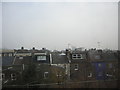
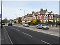
North Kensington skyline, from the West London Line
In the foreground, the Victorian terraces that characterise North Kensington. Dimly visible in the distance, on a misty morning, is Erno Goldfinger's iconic Trellick Tower.
Image: © Christopher Hilton
Taken: 2 Mar 2012
0.08 miles
3
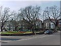
Junction of North Pole Road, St Quintin Avenue and Highlever Road
Image: © Tim Glover
Taken: 19 Mar 2005
0.09 miles
4
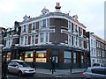
North Kensington Tesco Express
In a former pub (called the North Pole) on the junction of North Pole Road and Latimer Road (on the right).
Image: © David Anstiss
Taken: 6 Dec 2013
0.10 miles
5
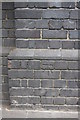
Benchmark on wall pier of North Pole Road near railway bridge
Ordnance Survey cut mark benchmark described on the Bench Mark Database at http://www.bench-marks.org.uk/bm38138
Image: © Roger Templeman
Taken: 27 May 2011
0.11 miles
6
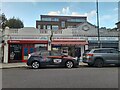
Shops on North Pole Road, North Kensington
Image: © David Howard
Taken: 26 Oct 2023
0.12 miles
8
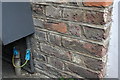
Benchmark on #7 The Triangle (St Quintins Gardens)
Ordnance Survey cut mark benchmark described on the Bench Mark Database at http://www.bench-marks.org.uk/bm38139
Image: © Roger Templeman
Taken: 27 May 2011
0.13 miles
9
The Pavilion public house, North Kensington
Image: © Stacey Harris
Taken: 30 Aug 2011
0.14 miles
10
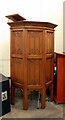
St Helen, St Helen's Gardens, North Kensington - Pulpit
Image: © John Salmon
Taken: 30 Apr 2010
0.14 miles