IMAGES TAKEN NEAR TO
St. Helens Gardens, LONDON, W10 6LW
Introduction
This page details the photographs taken nearby to St. Helens Gardens, W10 6LW by members of the Geograph project.
The Geograph project started in 2005 with the aim of publishing, organising and preserving representative images for every square kilometre of Great Britain, Ireland and the Isle of Man.

There are currently over 7.5m images from over14,400 individuals and you can help contribute to the project by visiting https://www.geograph.org.uk
Image Map
Images are licensed for reuse under creativecommons.org/licenses/by-sa/2.0
Notes
- Clicking on the map will re-center to the selected point.
- The higher the marker number, the further away the image location is from the centre of the postcode.
Image Listing (113 Images Found)
Images are licensed for reuse under creativecommons.org/licenses/by-sa/2.0
Image
Details
Distance
1
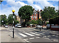
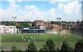
Crossing St Helens Gardens
Several streets round here are "Gardens".
Wishful thinking possibly, although it's all quite leafy.
Image: © Des Blenkinsopp
Taken: 30 Jul 2015
0.03 miles
2
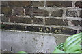
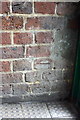
Benchmark on the side of #112 Oxford Gardens
Ordnance Survey cut mark benchmark described on the Bench Mark Database at http://www.bench-marks.org.uk/bm38106
Image: © Roger Templeman
Taken: 27 May 2011
0.03 miles
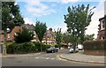
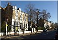
3
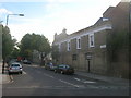
Cambridge Gardens W10
From the junction with St Helen's Gardens W10
Image: © Robin Sones
Taken: 8 Sep 2009
0.03 miles
4
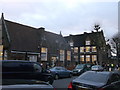
Oxford Gardens Primary School
On Oxford Gardens (road).
Image: © David Anstiss
Taken: 6 Dec 2013
0.05 miles
5
Benchmark inside Robinson House
Ordnance Survey cut mark benchmark described on the Bench Mark Database at http://www.bench-marks.org.uk/bm38105
Image: © Roger Templeman
Taken: 27 May 2011
0.05 miles
6
Finstock Road
I took this one because Finstock is a village near where I live in Oxfordshire.
I was wondering what the connection is with North Kensington, but then realized I was walking along Oxford Gardens, so why not.
Image: © Des Blenkinsopp
Taken: 30 Jul 2015
0.06 miles
7
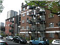
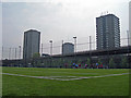
Robinson House, Bramley Road, W10
Showing, in the background, the tower blocks of the Silchester West Estate.
Image: © Danny P Robinson
Taken: 29 Apr 2007
0.06 miles
10
Cambridge Gardens W10
With the traffic lights at the crossroads with St Mark's Road on the right.
Image: © Derek Harper
Taken: 19 Mar 2012
0.09 miles