IMAGES TAKEN NEAR TO
St. Marks Road, LONDON, W10 6JZ
Introduction
This page details the photographs taken nearby to St. Marks Road, W10 6JZ by members of the Geograph project.
The Geograph project started in 2005 with the aim of publishing, organising and preserving representative images for every square kilometre of Great Britain, Ireland and the Isle of Man.

There are currently over 7.5m images from over14,400 individuals and you can help contribute to the project by visiting https://www.geograph.org.uk
Image Map
Images are licensed for reuse under creativecommons.org/licenses/by-sa/2.0
Notes
- Clicking on the map will re-center to the selected point.
- The higher the marker number, the further away the image location is from the centre of the postcode.
Image Listing (152 Images Found)
Images are licensed for reuse under creativecommons.org/licenses/by-sa/2.0
Image
Details
Distance
1
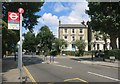
Oxford Gardens Bus Stop
Oxford Gardens crosses St Marks Road.
Image: © Des Blenkinsopp
Taken: 30 Jul 2015
0.03 miles
2
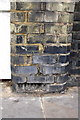
Damaged benchmark on wall of Roebuck House, St Marks Road
Ordnance Survey cut mark benchmark described on the Bench Mark Database at http://www.bench-marks.org.uk/bm38027
Image: © Roger Templeman
Taken: 20 May 2011
0.06 miles
3
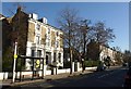
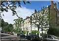
Cambridge Gardens W10
With the traffic lights at the crossroads with St Mark's Road on the right.
Image: © Derek Harper
Taken: 19 Mar 2012
0.06 miles
5
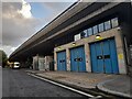
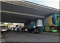
Westway from Malton Road, North Kensington
North Kensington Ambulance Station is under the bridge.
Image: © David Howard
Taken: 26 Oct 2023
0.07 miles
6
Oxford Gardens
Terraces of imposing, large houses along here, with front doors on the first floor over a sunken ground floor, then two more floors with loft space above by the look of the little window at the end.
Image: © Des Blenkinsopp
Taken: 30 Jul 2015
0.07 miles
7
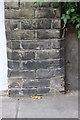
Benchmark on the wall end pier between #76 and #78 Cambridge Gardens
Ordnance Survey cut mark benchmark described on the Bench Mark Database at http://www.bench-marks.org.uk/bm38024
Image: © Roger Templeman
Taken: 20 May 2011
0.08 miles
8

Westway from an underground train west of Ladbroke Grove
Image: © Christopher Hilton
Taken: 8 Aug 2013
0.09 miles
9
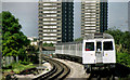
Ladbroke Grove station, London
A Hammersmith – Liverpool Street train of “C” stock approaching Ladbroke Grove http://www.geograph.org.uk/search.php?i=28439650
Image: © Albert Bridge
Taken: 16 Jun 1991
0.10 miles
10
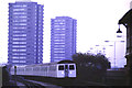
London Underground approaching Ladbroke Grove
A London Underground train approaching Ladbroke Grove station on a gloomy November day.
Image: © Malc McDonald
Taken: 29 Nov 1985
0.10 miles