IMAGES TAKEN NEAR TO
Cambridge Gardens, LONDON, W10 6JD
Introduction
This page details the photographs taken nearby to Cambridge Gardens, W10 6JD by members of the Geograph project.
The Geograph project started in 2005 with the aim of publishing, organising and preserving representative images for every square kilometre of Great Britain, Ireland and the Isle of Man.

There are currently over 7.5m images from over14,400 individuals and you can help contribute to the project by visiting https://www.geograph.org.uk
Image Map
Images are licensed for reuse under creativecommons.org/licenses/by-sa/2.0
Notes
- Clicking on the map will re-center to the selected point.
- The higher the marker number, the further away the image location is from the centre of the postcode.
Image Listing (218 Images Found)
Images are licensed for reuse under creativecommons.org/licenses/by-sa/2.0
Image
Details
Distance
1
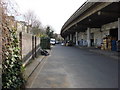
Malton Road
Here light industry is housed under an elevated section of the A40 Westway road
Image: © Oxyman
Taken: 4 Apr 2008
0.01 miles
2
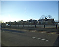
Westway by Ladbroke Grove
Until Transport for London in the early 2000s this was the A40(M) motorway with a 60mph speed limit. It turned out TfL didn't have power over motorways so they downgraded it to an A road, removed the street lighting and dropped the limit to 40. Don't ask me why, it worked perfectly well for around 40 years exactly as it was but TfL have dropped the speed limit on nearly every trunk road by 10-20mph. The backs of the houses are on Cambridge Gardens.
Image: © David Howard
Taken: 1 Mar 2014
0.01 miles
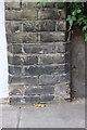
4
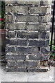
Benchmark on the wall end pier between #55 and #57 Cambridge Gardens
Ordnance Survey cut mark benchmark described on the Bench Mark Database at http://www.bench-marks.org.uk/bm38023
Image: © Roger Templeman
Taken: 20 May 2011
0.04 miles
5
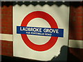
Ladbroke Grove station sign
Taken on the eastbound platform at Ladbroke Grove station.
Image: © Phillip Perry
Taken: 6 Feb 2007
0.04 miles
6
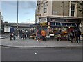
Cambridge Gardens at the junction of Ladbroke Grove
Looking towards the Westway flyover.
Image: © David Howard
Taken: 26 Oct 2023
0.05 miles
7
Benchmark on the wall end pier between #76 and #78 Cambridge Gardens
Ordnance Survey cut mark benchmark described on the Bench Mark Database at http://www.bench-marks.org.uk/bm38024
Image: © Roger Templeman
Taken: 20 May 2011
0.05 miles
8
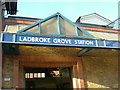
Ladbroke Grove station entrance
Entrance to the Hammersmith & City Line station Ladbroke Grove, North Kensington, W10
Image: © Phillip Perry
Taken: 6 Feb 2007
0.05 miles
9
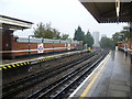
Ladbroke Grove station
What is now Ladbroke Grove station opened on 13th June 1864 and was served by two existing railway lines – the Hammersmith & City Railway which opened on the same day (owned by the Great Western Railway and running between Westbourne Park and Hammersmith stations) and the West London Railway (WLR) which opened just over two weeks later on 1st July 1864 and left this line at what is now Latimer Road to reach Addison Road (now Kensington Olympia). The link to Addison Road was closed on 19th October 1940.
The station was originally opened as 'Notting Hill' It was renamed 'Notting Hill (Ladbroke Road)' in 1869, 'Notting Hill & Ladbroke Grove' in 1880 and 'Ladbroke Grove (North Kensington)' in 1919 before acquiring the present name in 1938.
Trains on the Hammersmith & City Line serve the station and now also, in an effort to improve its reliability, the Circle Line. The next station in this direction is Latimer Road. The afternoon was quite as miserable as it looks in the photograph.
Image: © Marathon
Taken: 6 Nov 2013
0.05 miles
10
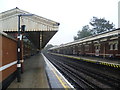
Ladbroke Grove station
What is now Ladbroke Grove station opened on 13th June 1864 and was served by two existing railway lines – the Hammersmith & City Railway which opened on the same day (owned by the Great Western Railway and running between Westbourne Park and Hammersmith stations) and the West London Railway (WLR) which opened just over two weeks later on 1st July 1864 and left this line at what is now Latimer Road to reach Addison Road (now Kensington Olympia). The link to Addison Road was closed on 19th October 1940.
The station was originally opened as 'Notting Hill' It was renamed 'Notting Hill (Ladbroke Road)' in 1869, 'Notting Hill & Ladbroke Grove' in 1880 and 'Ladbroke Grove (North Kensington)' in 1919 before acquiring the present name in 1938.
Trains on the Hammersmith & City Line serve the station and now also, in an effort to improve its reliability, the Circle Line. The next station in this direction is Westbourne Park. The afternoon was quite as miserable as it looks in the photograph.
Image: © Marathon
Taken: 6 Nov 2013
0.05 miles