IMAGES TAKEN NEAR TO
Barlby Road, LONDON, W10 6BH
Introduction
This page details the photographs taken nearby to Barlby Road, W10 6BH by members of the Geograph project.
The Geograph project started in 2005 with the aim of publishing, organising and preserving representative images for every square kilometre of Great Britain, Ireland and the Isle of Man.

There are currently over 7.5m images from over14,400 individuals and you can help contribute to the project by visiting https://www.geograph.org.uk
Image Map
Images are licensed for reuse under creativecommons.org/licenses/by-sa/2.0
Notes
- Clicking on the map will re-center to the selected point.
- The higher the marker number, the further away the image location is from the centre of the postcode.
Image Listing (218 Images Found)
Images are licensed for reuse under creativecommons.org/licenses/by-sa/2.0
Image
Details
Distance


3

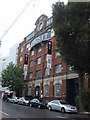
Pall Mall depository - Barlby Road, W10
The former Pall Mall depository in Barlby Road.
Image: © Phillip Perry
Taken: 19 Jul 2008
0.05 miles

5
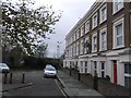
Admiral Mews
Short road of housing leading of Barlby Road.
Beyond the houses is part of the railway works from Westbourne Park to Acton Main line.
Image: © David Anstiss
Taken: 6 Dec 2013
0.06 miles
9

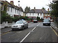
Hewer Street, W10
3 different types of flats.
Image: © Phillip Perry
Taken: 19 Jul 2008
0.08 miles