IMAGES TAKEN NEAR TO
Blake Close, LONDON, W10 6AY
Introduction
This page details the photographs taken nearby to Blake Close, W10 6AY by members of the Geograph project.
The Geograph project started in 2005 with the aim of publishing, organising and preserving representative images for every square kilometre of Great Britain, Ireland and the Isle of Man.

There are currently over 7.5m images from over14,400 individuals and you can help contribute to the project by visiting https://www.geograph.org.uk
Image Map
Images are licensed for reuse under creativecommons.org/licenses/by-sa/2.0
Notes
- Clicking on the map will re-center to the selected point.
- The higher the marker number, the further away the image location is from the centre of the postcode.
Image Listing (68 Images Found)
Images are licensed for reuse under creativecommons.org/licenses/by-sa/2.0
Image
Details
Distance
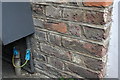
5
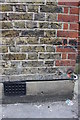
Benchmark on #116 Delgarno Gardens
Ordnance Survey cut mark benchmark described on the Bench Mark Database at http://www.bench-marks.org.uk/bm38118
Image: © Roger Templeman
Taken: 27 May 2011
0.07 miles
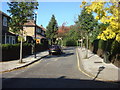
6
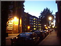
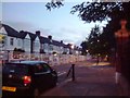
Sutton Way, W10
Part of the Sutton Estate in North Kensington.
Image: © Phillip Perry
Taken: 19 Jul 2008
0.08 miles
7
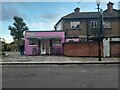
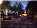
Belle's Tanning Studio on Dalgarno Road, North Kensington
Image: © David Howard
Taken: 26 Oct 2023
0.09 miles
9
Benchmark on #7 The Triangle (St Quintins Gardens)
Ordnance Survey cut mark benchmark described on the Bench Mark Database at http://www.bench-marks.org.uk/bm38139
Image: © Roger Templeman
Taken: 27 May 2011
0.11 miles