IMAGES TAKEN NEAR TO
Dalgarno Gardens, LONDON, W10 6AD
Introduction
This page details the photographs taken nearby to Dalgarno Gardens, W10 6AD by members of the Geograph project.
The Geograph project started in 2005 with the aim of publishing, organising and preserving representative images for every square kilometre of Great Britain, Ireland and the Isle of Man.

There are currently over 7.5m images from over14,400 individuals and you can help contribute to the project by visiting https://www.geograph.org.uk
Image Map
Images are licensed for reuse under creativecommons.org/licenses/by-sa/2.0
Notes
- Clicking on the map will re-center to the selected point.
- The higher the marker number, the further away the image location is from the centre of the postcode.
Image Listing (47 Images Found)
Images are licensed for reuse under creativecommons.org/licenses/by-sa/2.0
Image
Details
Distance
1
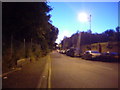
Mitre Way, W10
On the left is the West London railway line, on the right is Little Wormwood Scrubs. At the end of this road is some industrial units.
Image: © Phillip Perry
Taken: 19 Jul 2008
0.02 miles
2
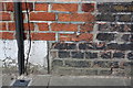
Benchmark on Brewster Gardens face of #18 Dalgarno Gardens
Ordnance Survey cut mark benchmark described on the Bench Mark Database at http://www.bench-marks.org.uk/bm38135
Image: © Roger Templeman
Taken: 27 May 2011
0.02 miles
3
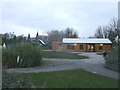
Little Wormwood Scrubs Playpark
Close to Dalgarno Gardens.
Image: © David Anstiss
Taken: 6 Dec 2013
0.03 miles
4
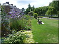
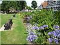
The garden in Little Wormwood Scrubs
The area was separated from the main body of Wormwood Scrubs by the construction of the Birmingham, Bristol & Thames Junction Railway in 1844 (now part of London Overground). Like its larger western neighbour, Little Wormwood Scrubs had been used for common grazing throughout its ownership by the Bishops of London. One area of the site was purchased for use as a rifle range in the 1840s and various other sections became the victims of railway and road development. The remaining area of open space was acquired by the Metropolitan Board of Works in 1886 and is now owned by the London Borough of Hammersmith and Fulham.
These gardens are along the south-eastern corner, alongside Dalgarno Gardens.
Image: © Marathon
Taken: 23 Jul 2014
0.04 miles
5
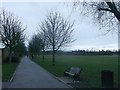
Path in Little Wormwood Scrubs
A circular path leads around the outer limits on the rough parkland in North Kensington.
Image: © David Anstiss
Taken: 6 Dec 2013
0.05 miles
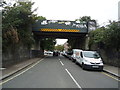
6
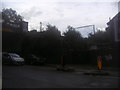
Railway line by Dalgarno Gardens, North Kensington
Image: © David Howard
Taken: 25 Aug 2012
0.06 miles
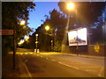
7

Texaco filling station - Scrubs Lane, W10
Image: © Phillip Perry
Taken: 19 Jul 2008
0.06 miles
9
The garden in Little Wormwood Scrubs
The area was separated from the main body of Wormwood Scrubs by the construction of the Birmingham, Bristol & Thames Junction Railway in 1844 (now part of London Overground). Like its larger western neighbour, Little Wormwood Scrubs had been used for common grazing throughout its ownership by the Bishops of London. One area of the site was purchased for use as a rifle range in the 1840s and various other sections became the victims of railway and road development. The remaining area of open space was acquired by the Metropolitan Board of Works in 1886 and is now owned by the London Borough of Hammersmith and Fulham.
These gardens are along the south-eastern corner, alongside Dalgarno Gardens.
Image: © Marathon
Taken: 23 Jul 2014
0.06 miles