IMAGES TAKEN NEAR TO
Orchard Close, LONDON, W10 5RA
Introduction
This page details the photographs taken nearby to Orchard Close, W10 5RA by members of the Geograph project.
The Geograph project started in 2005 with the aim of publishing, organising and preserving representative images for every square kilometre of Great Britain, Ireland and the Isle of Man.

There are currently over 7.5m images from over14,400 individuals and you can help contribute to the project by visiting https://www.geograph.org.uk
Image Map
Images are licensed for reuse under creativecommons.org/licenses/by-sa/2.0
Notes
- Clicking on the map will re-center to the selected point.
- The higher the marker number, the further away the image location is from the centre of the postcode.
Image Listing (283 Images Found)
Images are licensed for reuse under creativecommons.org/licenses/by-sa/2.0
Image
Details
Distance
1
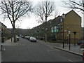
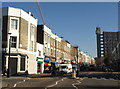
Wornington Road, W10 (2)
Near Orchard Close.
Image: © Danny P Robinson
Taken: 4 Feb 2007
0.02 miles
2
Wall on Portobello Road
The northeastern end of Portobello Road beyond the Hammersmith and City line and A40 bridges is lined with a very interesting wall which has plastic boarding with the spines of LP sleeves on it. I suppose this has been done in order to reflect the number of record shops and stalls in the area. I'm not sure if this is a recent idea or one that has been here for some time - the Streetview of the location (as near as I could get it, the car obviously hasn't covered this section of the road) (http://www.google.co.uk/maps?f=q&source=s_q&hl=en&geocode=&q=Portobello+Road,+Kensington&sll=53.800651,-4.064941&sspn=20.594096,62.53418&ie=UTF8&hq=&hnear=Portobello+Rd,+Kensington,+Greater+London,+United+Kingdom&ll=51.521076,-0.209619&spn=0.021095,0.061069&z=15&layer=c&cbll=51.521076,-0.209619&panoid=MTtW7bTtmJP80DrNBKKxNQ&cbp=12,134.4,,0,2.87) doesn't show it being there. It's certainly a very inventive and thoughtful idea! Looking east-southeast.
Image: © Robert Lamb
Taken: 20 Nov 2010
0.05 miles
3
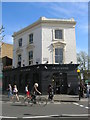
The Fat Badger, Goldborne Road, London W10
At the Junction with Bevington Road, London W10
Image: © Robin Sones
Taken: 26 Apr 2008
0.06 miles
4
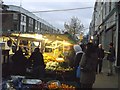
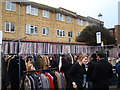
Part of Golborne Road market
Still busy and vibrant even at dusk (due to the stall lights).
The road hosts a street market every day except Sunday, specialising in produce with hot food and bric-a-brac at the weekend.
Image: © David Anstiss
Taken: 6 Dec 2013
0.08 miles
5
View of Trellick Tower from Acklam Road
Looking north-northeast.
Image: © Robert Lamb
Taken: 4 Dec 2016
0.08 miles
6
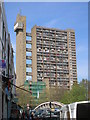
Golborne Road, London W10
Looking towards Trellick Tower - the bridge in the picture straddles the Metropolitan and City Underground line.
Image: © Robin Sones
Taken: 26 Apr 2008
0.09 miles
7
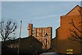
Benchmark on roadside wall of former Dominican Convent on Portobello Road
Ordnance Survey cut mark benchmark described on the Bench Mark Database at http://www.bench-marks.org.uk/bm38030
Image: © Roger Templeman
Taken: 20 May 2011
0.09 miles
8
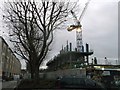
Construction work on Munro Mews
This will be eventually 'Portabello Square'. Happily the row of London Plane trees seem to have been spared.
Part of Kensington and Chelsea councils 'Housing regeneration' plans for the Wornington Green Estate. On the left is a finished new block of housing.
Even at dusk on a Friday evening, plenty of work going on-site.
Image: © David Anstiss
Taken: 6 Dec 2013
0.09 miles
9
Golborne Road, W10
Seen across the junction with Portobello Road. Dark grey on the right is Trellick Tower.
Image: © Derek Harper
Taken: 19 Mar 2012
0.09 miles
10
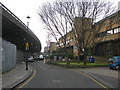
Acklam Road, W10
The flyover to the left of the picture carries the busy A40 Westway. I do not know if the local authority flats on the right hand side were built before or after the flyover -- it must be an extremely noisy and polluted environment in which to live.
Image: © Danny P Robinson
Taken: 4 Feb 2007
0.09 miles